

Fire Tower Walk, Dryandra Woodland Fire Tower Walk, Dryandra Woodland
Part of
Dryandra Woodland
network

Trails WA supports the seven principles recommended by Leave No Trace Australia for minimising your impacts when using the trails.
Learn moreAbout Fire Tower Walk, Dryandra Woodland
Dryandra Woodland features the largest area of remnant vegetation in the western Wheatbelt and forms part of an international biodiversity ‘hotspot’ where more than 850 species of plants can be seen. The woodland of wandoo, kwongan (the Aboriginal word for heath and shrublands), mallee, sheoak thickets and plantations of brown mallet is home to the numbat, Western Australia’s state fauna emblem. It is also home to other threatened and remarkable fauna such as the red-tailed phascogale, woylie, western grey kangaroo, tammar wallaby, brushtail possum and echidna as well as a diverse variety of reptiles and insects.
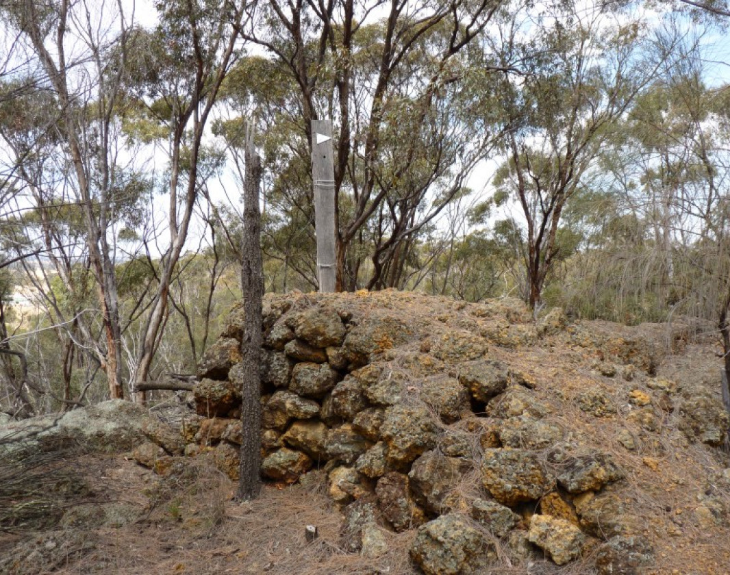
The remains of two historical fire lookout towers can be found along the trail.
Dryandra Country Visitor Centre (Narrogin)
(08) 9881 2064
- [email protected]
- Visit website
- Corner Park and Fairway Street, Narrogin WA 6312
Other Links
-
Lions Dryandra Village
Cottage accommodation
-
Barna Mia
Nocturnal animal tours
-
Australia’s Golden Outback
Comprehensive information on the Golden Outback region including destinations, things to see and do, accommodation and tours.
Be trail ready for Fire Tower Walk, Dryandra Woodland
Here is everything you need to know before visiting this trail.
Time / Duration
15 minutes
Length
450m return
What To Pack
Group B - Hiking & Long Distance Trails (Bushwalks and/or longer trails) required.
What To Pack
Group B - Hiking & Long Distance Trails (Bushwalks and/or longer trails)
- Sun protection: hat, sunglasses, and sunscreen (SPF 30+)
- Insect repellent
- Plenty of drinking water (as a minimum carry and drink 1 litre of water per hour of walking, per person).
- PLB or satellite phone
- Clothing to suit the activity, environment and weather conditions.
- Map/ Compass, do not rely on your phone in remote locations.
- Snacks/ Meals to keep your energy levels up on longer walks
- Extra food and water in case of unexpected delays
- Rubbish bag to remove all your rubbish
- Reference material such as wildflower wildlife guides.
- Whistle (for emergencies, six short blasts per minute)
- Small trowel for toilet emergencies, and a few sheets of toilet paper in a small waterproof bag.
- Personal first aid kit (check that items are clean, properly sealed, have not exceeded expiry dates and that used items have been replaced).
- Torch/ Headlamp
- Binoculars and camera (optional)
Trail Start
Contine Hill picnic area, Rosedale Road, near Dryandra, 200km (2.5hours) south east of Perth

Bush Walk
Class 2
Easy trail with modified or hardened surface, and gentle hills or occasional steps. Clear directional signage. No bushwalking experience required. May be suitable for assisted wheelchair users (if ramps are provided at steps).
Visit Trail Tips for further information.
Facilities
The nearest facilities are at Dryandra village, 30km away- Car Park
- Picnic Area
Best time of year
April- November
Trail Access
By road to Rosedale Road, off Congelin-Narrogin Road, 200km (2.5hours) south east of Perth


Complete Fire Tower Walk, Dryandra Woodland to earn badges and points!
Earn points and badges and become a "TrailsWA Expert" by completing trails and leaving reviews.
Earn 1 point towards
your TrailsWA level


Be the first to review Fire Tower Walk, Dryandra Woodland
We love to hear from people who've been on our Western Australian trails, so it would be most appreciated it if you wanted to leave a review.
Add your review of Fire Tower Walk, Dryandra Woodland
Like this trail? Explore others nearby
More around Golden Outback


Stokes Heritage Trail, Stokes NP, Esperance
-
 1-3 hours
-
6.4km

Skinny Dip Bay Walk, Woody Island Nature Reserve
-
Less than 1 hour
-
1.5km


Supported by great organisations
Trails are free and bring so many benefits to our community by providing opportunities to have fun, get fit, socialise, explore and challenge yourself. But they also have to be managed and maintained which only is made possible through terrific sponsors, donations and/or volunteering.


Remains of fire lookout tower

Views along the trail

Firetower remains
View 3 Photos of Fire Tower Walk, Dryandra Woodland
Upload your photo of Fire Tower Walk, Dryandra Woodland
Report a Problem
You are reporting a problem for Fire Tower Walk, Dryandra Woodland. Please be as detailed as possible to help us appropriately identify and address the issue.
