Skip to Content Skip to Navigation Show Trail Map Show About the Trail Show Important Trail Details Read Trail Reviews
Support Our Trails

Echidna Trail, Walyunga NP Echidna Trail, Walyunga NP
  • Half day
  • 11 km
    • Bush Walk Class 4

      Difficult trail with rough surface that may have very steep hills or extensive rock hopping. Directional signage may be limited. Bushwalking experience, navigation and emergency first aid skills, and good fitness required.

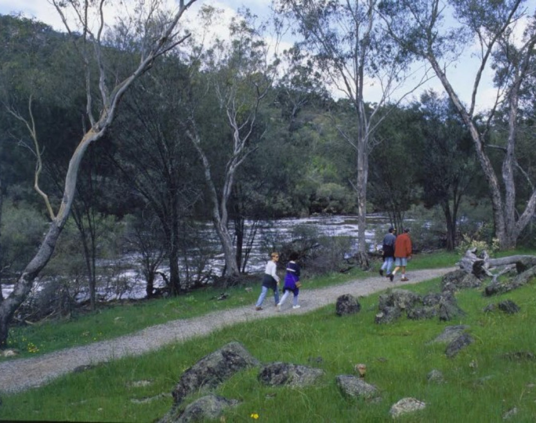
This 11 kilometre loop trail in Walyunga National Park initially follows the Avon River before it ascends steeply to the western side of the river.  It passes through marri and wandoo woodland, currently with a thick understorey of regrowth after fire, before offering good views of the Avon Valley from Woodsome Hill.

Trail beside river
Earn 3 Points
Logo for Leave no Trace Initiative

Trails WA supports the seven principles recommended by Leave No Trace Australia for minimising your impacts when using the trails.

Learn more

The track is rocky and involves some steep gravel ascents and descents.   In late winter and spring there are abundant wildflowers. The trail is marked with black footprints and is best walked in an anticlockwise direction. 

Walyunga National Park covers 1,800 hectares of the Darling Range, tucked behind the Darling Scarp, covering both sides of a steep valley.  Just to the east of the park, in the picturesque Avon Valley, the Avon River joins the Brockman River to form the Swan River which passes through the tree lined valley.

Walyunga contains one of the largest known Aboriginal campsites around Perth and was still in use by the Nyoongar people late last century. The area has been used as a meeting place for more than 6000 years. Walyunga is an Aboriginal name, but its meaning is uncertain.  Local Noongar people believe the Swan River was carved by the Waugal, and greet the dreamtime serpent here by rubbing sand on their bodies and throwing it in the water.

The Swan River is the main attraction in the park as it thunders through in winter and meanders by in the drier months, lined with smooth granite boulders. The Echinda trail starts beside the lower pool in Walyunga and follows the river past Syd's Rapids. It then ascends steeply to Woodsome Hill from where there are excellent views of the Avon Valley.  It passes through heathlands with hakeas, grevilleas, verticordias, hibbertias and triggerplants. Although the animals except for kangaroos are elusive during the day, there is a myriad of birdlife including galahs, parrots, black-faced cuckoo shrikes, thornbills and fantails. The trail is best walked anticlockwise, so as to avoid a slippery and steep descent. Its marker is a black footprint.

Other Links

  • Destination Perth

    Comprehensive information on the Perth region including destinations, things to see and do, accommodation and tours.


Be trail ready for Echidna Trail, Walyunga NP

Here is everything you need to know before visiting this trail.

Time / Duration

3 - 4 hours

Length

11km loop

Trail Start

The trail starts at the Walyunga Pool car park, Walyunga NP 1 hour north east of Perth

Get directions

Trail End

Bush Walk

Class 4

Difficult trail with rough surface that may have very steep hills or extensive rock hopping. Directional signage may be limited. Bushwalking experience, navigation and emergency first aid skills, and good fitness required.

Visit Trail Tips for further information.

Additional information

The steep ascents and descents make the trail suitable to experienced walkers.

What To Pack

Biodiversity

The Department of Biodiversity, Conservation and Attractions undertakes 1080 baiting at this location to reduce the impacts of feral cats and foxes on native wildlife. 

Meat baits containing 1080 poison are laid in or around this area on an ongoing basis. 1080 is poisonous to humans and will kill domestic cats and dogs. Please leave your pets at home or prevent them from entering this area.

For further information contact your local Parks and Wildlife Service office or visit Western Shield.

Facilities

  • BBQ Facilities
  • Camping
  • Car Park
  • Coach Parking
  • All accessible parking
  • Picnic Area
  • Public Toilet
  • Shaded Area
  • Sheltered Area

Best time of year

March to November Walyunga National Park is open daily from 8:00am to 5:00pm

Fees

National Park fees apply

Trail Access

Road 2WD

Prohibited Items

No pets or fires are permitted in the National Park
Edge shaped like mountain horizon
topography pattern

Complete Echidna Trail, Walyunga NP to earn badges and points!

Earn points and badges and become a "TrailsWA Expert" by completing trails and leaving reviews.

Earn 3 Points

Earn 3 points towards
your TrailsWA level

Edge shaped like mountain horizon
Alt text

23 trail goers have rated Echidna Trail, Walyunga NP as 4.04 out of 5!

We love to hear from people who've been on our Western Australian trails, so it would be most appreciated it if you wanted to leave a review.

Yu-Jun Wong

Reviewed 21 Oct 2023, 11:22am

Went anticlockwise, took about 2hrs 45 mins. I'm an inexperienced hiker and average fitness but it was good fun, the climb up is a bit challenging as the trail has many loose rocks and the initial portion when descending is also quite steep so be sure to have a good pair of shoes with grip. Saw a few kangaroos and also (weirdly) a lost sheep at the peak. Have fun!
Gary Roberts

Reviewed 1 Oct 2023, 3:41pm

Going anticlockwise it took me 2 hours and 40 minutes. I am an inexperienced hiker and had to stop frequently on the ascent to catch my breath. Didn’t see any wildlife today.
Jemma Day

Reviewed 16 Jul 2023, 4:21pm

This was our first ever trail walk. Moderate climbs in half a dozen places that got the heart going. We did it in just over 2hrs but set a pretty good pace. No echidnas but saw some kangaroos and great views of city and pretty bushland. Lots of people at the national park making the most of this beautiful sunny July day. Temp was 19 and very pleasant with blue skies. Would highly recommend.
Sarah Nicholson

Reviewed 4 Jun 2023, 7:30pm

The Echidna Trail is a fairly easy 11km loop track with well graded pathways and a short section of ascent. Beautiful scenery ranges from the river to city views and more, and this was a fabulous way to start hiking in WA!
Brendon Burns

Reviewed 30 May 2023, 2:21pm

Great short'ish hike... a couple of really steep hills that get the heart rate up. Terrific views of the Avon Valley from the top of the hill.
Olivia Birkett

Reviewed 27 May 2023, 7:01pm

Tough walk! I did it in the middle of a 30°C degree day and needed all the water I took. It was my first test of hiking poles and I needed them. Good fun! ☺️
Yvette Q

Reviewed 7 Apr 2023, 2:18pm

I am more of a relaxed walker than a serious hiker. I go slow, take breaks and get puffed-out by hills (I’ve very little cardio).

An 11km walk on flat ground would be a pleasant and easy walk for me. But with these steep hills, it was a “medium” challenge.

There were two notably steep climbs. My strategy was to go VERY slow and I stopped for a short break when out of breath. It took me about 15 minutes for each steep hill, including the breaks.

There were two other easier hills that were not too taxing.

It took me just under 3.5 hours, going at a very relaxed pace and including a few breaks.

The path is very well marked. The section by the river is beautiful. There are great views after the hill climb.

I saw some kangaroos, but no echidnas :(
Marion Braunl

Reviewed 25 Sep 2022, 8:32pm

Beautiful and challenging trail, feels a bit shorter than 11k. Gives you a good workout in 2h .
Chelle Fisher

Reviewed 14 Sep 2022, 10:40am

This is a challenging trail with some steep ascents/descents, one of those trails that I personally feel they have not graded high enough, based on other trails but it is an enjoyable trail if you like a good challenge and want to take in some beautiful views.
Coralie Sherwin

Reviewed 8 May 2022, 5:59pm

May 2022 - Group of 9 very chatty reasonably fit walkers completed this trail in about 2.5hrs. Anticlockwise. Nice to begin walking next to the river. Hills were enduring but not awful. Downhill a little steep, gravel made it a little slippery, many walking stick sized branches conveniently near the sides of the paths came in handy. May consider taking the hiking sticks next time. Most of trail was 4 wheel drive accessible. Much of the trail was reasonably shaded. Great views made the hills worth it. Plenty of kangaroos. Only downside was perhaps a lack of places (rocks or sitting logs) to stop for a little refreshment and morning tea along the way. Benches at the end/beginning of walk were appreciated!
Alexa Whitehorn

Reviewed 8 Oct 2021, 9:40am

I was SO excited when I spotted an echidna! I walked in a clockwise direction and completed it in 2 hours without a pack. I started at 8:30am and didn't see anyone for the first 7kms, but then it got a little busy (it was school holidays). I got to hang out with an echidna for ages while he was sniffing around! I kept my distance but he was pretty relaxed. Beautiful spot for a picnic and you can find some space to yourself if you walk down the river a bit.
Willow Barker

Reviewed 7 Dec 2020, 2:19pm

I am new to hiking so it's hard for me to know how to review. However I as one of my first hikes I enjoyed the challenge & changes in terrain.. I fount it a workout. I did it anticlockwise and think I prefer it this way so you get the steep descent done first. The first part along the river is lovely & peaceful and I agree its worth starting the trail at Walyunga Car park ( 1st car-park). Pity you cant get here earlier than 8am. I didn't really find a place I wanted to stop and picnic so I ended up having my snack back at the picnic spot next to the river which I enjoyed. As a solo hiker the $15 us a lot ( I think I'll look into getting a WA NP annual pass) Took me 2 hours & 50 mins.
Michael Sargeant

Reviewed 1 Jul 2020, 6:24pm

I did the track anti clockwise today with a light pack in about two and a half hours and quite enjoyed it. There's a self service payment machine at the entry to the park which only takes cards, and a gate that is opened 8am-5pm each day. As others have said, the inclines that start after Syd's rapids can be tough at times, but its all downhill for about the last quarter, which gets you quickly to the end. The track passes through a good number of changes in landscape and flora, and now its Winter with everything quite green and a few flowering plants and fungi to be seen. I encountered plenty of kangaroos and lots of different birdlife, but unfortunately no echidnas. I'll definitely be back in Spring when more of the wildflowers are blooming.
Chris Nener

Reviewed 22 Oct 2017, 6:30pm

A nice trail. Anti-clockwise it starts off following Long Pond to Syds Rapids before it gets to the incline, certainly got puffed heading up but nothing too strenuous. Saw plenty of bird life and kangaroos. The views from the top are beautiful as well. Clearly signed. Can be finished in around 2.5 - 3 hours without a pack.
Irina Guidara

Reviewed 30 Sep 2017, 10:15pm

Today my friends and I complete this trail. There were 4 adults, one - eight year old and my friend was also caring a baby in a baby carrier. It was quite a challenge as kids got tired and we had to stop for them. We went anti-clockwise and completed it in four hours. Trail was well marked with clear signage. But we have noticed that most of people completed the trail in clockwise direction as supposibly it is easier this way. I really enjoyed the trail and would definitely do it again in the same direction.
Peter Harrison

Reviewed 30 Jul 2017, 8:01pm

I walked the perimeter today, the hills are pretty challenging but I'm a fit-ish 55 and managed them relatively easily. Some great outlooks, was fortunate to see a freight train pass through when I was nearing the top. I will be back soon, but not when the Avon decent is on
Georgia Villaflor

Reviewed 17 Oct 2016, 9:52am

Walked this trail about a week ago, it was my first trail in Perth. It starts off fairly relaxed but gets quiet steep in places and I would say over half is a difficult incline so be aware of that when taking packs. There is clear signage throughout and you get a great view.
naomi patchett

Reviewed 6 Oct 2016, 6:50pm

Hello, I did this trail on Tuesday. Probably not a good one to try out a new pack that I loaded with 8kg on. Lots of hills that are quite steep. A very enjoyable walk with lots to see. Felt so great when I got to the car lol need to toughen up on hills.
Emma Adams

Reviewed 7 Jul 2016, 5:01pm

Loved this trail. Everything felt so lush and green despite the minimal rains (at the time I went). There are some steep sections, but nothing unmanageable, and the trail is easy to follow. I think we completed it in a bit less than 3 hours, but it could be quicker too. Saw lots of kangaroos which was really cool. Plan on going back after a rainy period to see how the trail has changed. Definitely recommend doing this trail.
lavinia wilson

Reviewed 5 Apr 2016, 4:03pm

walked this trail on the weekend and also found it clearly signed and easy to follow. the start of the trail, beside the river, was lovely and we were lucky that the water was flowing . i had to stop a few times during the steep sections but that is only because i'm not as fit as i once was. great views from the top . saw kangaroos and lots of birds. considering it's the end of summer was also surprised at how green it was. can imagine in winter and when the wildflowers are out this walk will be quite pretty . great day !
Jason Jenke

Reviewed 7 Mar 2016, 9:03pm

I walked this trail today. I found the trail to be clearly signed and easy to follow. I thoroughly recommend this trail and I really enjoyed the terrain. With the regeneration of the bush and the multitudes of rocky outcrops , the views and the kangaroos were around every corner. I'll definitely be back.
Paul Prescott

Reviewed 12 Jan 2016, 3:39pm

I walked this trail for the 1st time today. Whether the signs have been recently replaced I cannot say - but I found the signage to be clear and easy to follow as long as you walk the trail anti-clockwise. Quite steep in places but well worth the effort. The vegetation has clearly suffered from a fire in the not too distant past but is quite varied along the way. One I will do again.
Ally Catt

Reviewed 11 Oct 2015, 12:19pm

This trail is quite terribly signed. Met people in the carpark who turned around because they got lost. We missed 2 signs (even though we were paying special attention to find them) because the track was overgrown and main trails leading off without signs to say which trail it is youre following.. can totally understand how they got lost. The walk is signed as grade 4 in the park and its quite hilly but totally worth the hike if youre careful to not get lost! Saw some roos and plenty of birds along the way
a good adventure.

Like this trail? Explore others nearby

More around Perth & Surrounds

Supported by great organisations

Trails are free and bring so many benefits to our community by providing opportunities to have fun, get fit, socialise, explore and challenge yourself. But they also have to be managed and maintained which only is made possible through terrific sponsors, donations and/or volunteering.

topography pattern