Skip to Content Skip to Navigation Show Trail Map Show About the Trail Show Important Trail Details Read Trail Reviews
Support Our Trails

Peak Charles Trail, Peak Charles NP Peak Charles Trail, Peak Charles NP

  • 1-3 hours
  • 3.2 km
    • Bush Walk Class 4

      Difficult trail with rough surface that may have very steep hills or extensive rock hopping. Directional signage may be limited. Bushwalking experience, navigation and emergency first aid skills, and good fitness required.

The Peak Charles Trail is a 3.2km return trail in the Peak Charles National Park. From the summit hikers can see 50 kilometres in all directions, with sweeping views of the surrounding Frank Hann National Park.

Earn 3 Points Tall Peak
Logo for Leave no Trace Initiative

Trails WA supports the seven principles recommended by Leave No Trace Australia for minimising your impacts when using the trails.

Learn more

Peak Charles differs markedly from other rock outcrops in the region in size, height and steepness. The trail to the summit consists of three sections. The sections you choose to do will depend on your level of fitness, how well equipped you are and weather conditions.

MUSHROOM ROCK

Moderate incline, rough surfaces, very slippery when wet.

Height: 295 metres Total distance from here: 600 metres return (allow 45 minutes)

The start of the trail is well defined and has no markers. It takes you through open woodland across mildly undulating terrain with loose rocks to exposed rock at the base of Peak Charles. From this point the trail is marked by white-tipped poles.  Some high stepping onto rocks is required. This section of the trail ends at Mushroom Rock, one of many intriguing rock formations on the slopes of Peak Charles.

CENTRAL RIDGE

Steep incline, rough, unstable surfaces. Very slippery when wet. Strong winds.

Height: 460 metres Total distance from here 2.2km return (allow 2 hours)

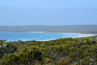
This section of the trail, which is marked by white-tipped poles inserted into rock cairns, is much steeper and has large loose rocks. It requires frequent high stepping and handholds to get up in places. There is also some rock scrambling. The trail traverses up bare rock and through vegetated areas to a saddle on the southeast ridge that offers sweeping views over the woodlands, sandplain heaths and salt lake systems of the surrounding countryside.  

PEAK CHARLES SUMMIT

Exceeds walktrail classification as this section requires frequent rock scrambling.

Very steep, exposed incline. Rough surfaces. Very slippery when wet. Strong winds.

Height: 651 metres

Total distance from here: 3.4km return (allow 3 hours)

This section of the trail is very steep and requires foot and hand placement in crevices to pull yourself up in places. You must be able to lift your own weight several times. There are no markers and you mst be able to find and assess appropriate hand and foot holds. On the descent you have to crab crawl on your hands and feet with your back to the rock. If you are short you may need to be pulled up in a few places on the ascent by another person and you will have to slide down some short sections of steep on the descent. The summit is largely bare and marked by a tall rock cairn.

Esperance Visitor Centre

(08) 9038 1555

National Parks

Other Links

Be trail ready for Peak Charles Trail, Peak Charles NP

Here is everything you need to know before visiting this trail.

Time / Duration

2 - 3 hours

Length

1.6 kilometres to the summit, 3.2 kilometres return

What To Pack

Group B - Hiking & Long Distance Trails (Bushwalks and/or longer trails) required.

Trail Start

Peak Charles National Park is 507km (5 hours) east of Perth and 174km (2 hours) NW of Esperance.

Get directions

Trail End

Get directions

Bush Walk

Class 4

Difficult trail with rough surface that may have very steep hills or extensive rock hopping. Directional signage may be limited. Bushwalking experience, navigation and emergency first aid skills, and good fitness required.

Visit Trail Tips for further information.

Difficulty Notes

Beyond the lookout there is no easy way up the final rock slopes to the summit and no route is recommended. All routes require some exposed rock scrambling and steady footing on steeply angled slopes.

Hazards & Warnings

Trail has a natural surface of granite and rock so caution is advised. If wet or windy do not attempt steep rocky bare sections of the trail. Take extreme care near steep slopes. Stay away from cliff edges.

Facilities

The campground has no facilities - so you'll need to be self-sufficient and take your own water and cooking equipment.
Interpretive panels at the campground give more information about Peak Charles.
  • Camping
  • Car Park
  • Interpretive Centre
  • Lookouts
  • Public Toilet

Best time of year

All year round except in wet or windy conditions.

Fees

National Park fees

Trail Access

The road accessing the park is gravel and a four-wheel drive is recommended.

Prohibited Items

No pets in National Parks
Edge shaped like mountain horizon
topography pattern

Complete Peak Charles Trail, Peak Charles NP to earn badges and points!

Earn points and badges and become a "TrailsWA Expert" by completing trails and leaving reviews.

Earn 3 Points

Earn 3 points towards
your TrailsWA level

Tall Peak

Earn the Tall Peak badge when you complete this trail.

Edge shaped like mountain horizon
Alt text

2 trail goers have rated Peak Charles Trail, Peak Charles NP as 4 out of 5!

We love to hear from people who've been on our Western Australian trails, so it would be most appreciated it if you wanted to leave a review.

Alison Melvin

Reviewed 2 May 2023, 3:05pm

Mushroom Rock.Vegetation & smooth granite outcrops. zigzagging & small steps give good confidence in this 1st stage.
To Mushroom Rock. 1st stage
Steven, Mark & John reached 550m. The summit was 651m, needing rock accomplished experience to complete climb. I believe this could be a grade 5 walk / climb.Very steep and chain needed to reach summit for self satisfaction and safety.
Janine Doney

Reviewed 25 Apr 2019, 10:25am

If you climb to the top, allow 5 hours return trip. Stunning views, good phone reception at the site. School aged kids managed this climb well.

Like this trail? Explore others nearby

More around Golden Outback

Supported by great organisations

Trails are free and bring so many benefits to our community by providing opportunities to have fun, get fit, socialise, explore and challenge yourself. But they also have to be managed and maintained which only is made possible through terrific sponsors, donations and/or volunteering.

topography pattern