Skip to Content Skip to Navigation Show Trail Map Show About the Trail Show Important Trail Details Read Trail Reviews
Support Our Trails

Golden Pipeline Heritage Trail, Mundaring Weir to Kalgoorlie Golden Pipeline Heritage Trail, Mundaring Weir to Kalgoorlie

2WD  in Golden Outback

(+2)
Kalgoorlie & Goldfields, Wheatbelt & Wave Rock, Perth Hills

  • Multiple day
  • 650 km

The Golden Pipeline Heritage Trail takes you to WA’s Eastern Goldfields, rich in gold, history and scenery, revealing the story of a unique engineering feat. Travel on the old Goldfields Road along which fortune seekers rushed in the 1890s.

Southern Cross2 Golden Pipelineht Kstevens
Earn 1 Point
Logo for Leave no Trace Initiative

Trails WA supports the seven principles recommended by Leave No Trace Australia for minimising your impacts when using the trails.

Learn more

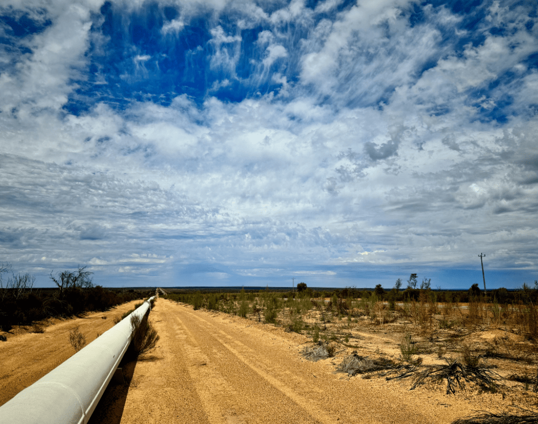
Stop to explore where they stopped to rest and fill their waterbags. Prospectors learned that water is more precious than gold - some died of thirst - and a scheme was devised to deliver water further and higher than ever before to supply the goldfields. The well-signposted Golden Pipeline Heritage Trail follows this life-giving water east from its source in the forested Perth Hills, through the golden expanses of the Wheatbelt to the gold boomtown of Kalgoorlie.

The Trail is a great way to learn about Western Australia, past and present and CY O'Connor, the engineer who designed the water scheme. The Golden Pipeline is so named because of the Golden Fleece (6 million sheep rely on it), the Golden Sheaves of the Wheatbelt and Gold from Australia’s richest goldfields.  The trail includes dams and wells built before the pipeline, natural attractions such as nature reserves, gold mining towns and abandoned town sites.

Apart from Goldfields Road, you travel on old Eastern Railway reserve, along which trains steamed, and the maintenance road alongside the water supply pipeline.  Only two small sections are unsuitable for caravans. A range of accommodation is available at towns en route.

The trail is ideal for motorists who have a couple of days or more to explore the history, hospitality and horizons of Golden Pipeline Country. There's plenty to get you out of your car: 100-year old pumping stations, remote sites where workers lived to keep the water flowing, walk trails around massive granite outcrops.

Water spends at least a week in the pipeline from source to destination and we recommend you too take your time to get the most from the trail. There are plenty of opportunties to stop, get out of the car and explore.  The 25 interpreted sites along the trail have illustrated informative signs to help you discover more and a comprehensive guide book will enhance your drive trail experience. 

The "Golden Pipeline Heritage Trail Guide"  packed with easy to read maps, photographs and information is available from good book stores in Perth and major WA towns, visitor centres and newsagents in Golden Pipeline Country and The National Trust’s website.

Access the Golden Pipeline Heritage Trail at Mundaring Weir if travelling west to east; or at Mount Charlotte on the outskirts of Kalgoorlie if travelling east to west. The Trail is well marked with large brown tourist roadside signs.  These indicate direction at major intersections and reassurance shield signs appear regularly along the route. All carry the distinctive Golden Pipeline logo.

National Trust of WA

(08) 9321 6088

Kalgoorlie Boulder Visitor Centre

(08) 9021 1966

Other Links

Be trail ready for Golden Pipeline Heritage Trail, Mundaring Weir to Kalgoorlie

Here is everything you need to know before visiting this trail.

Time / Duration

3 - 5 days

Length

650km

What To Pack

Group D (Drive trails) required.

Trail Start

Mundaring Weir, 34km (45 minutes) from Perth if travelling west to east; or at Mount Charlotte on the outskirts of Kalgoorlie if travelling east to west

Get directions

Trail End

Mount Charlotte Reservoir lookout overlooking Kalgoorlie- Boulder

Get directions

Facilities

Trail passes through towns, Some of the interpreted sites can be explored in wheelchairs. Contact The National Trust for further information.
  • Camping
  • Picnic Area
  • Public Toilet

Best time of year

September to November. The trail can be undertaken at any time of the year, but be aware of possible weather conditions. Summer temperatures are high.

Trail Access

Road

Edge shaped like mountain horizon
topography pattern

Complete Golden Pipeline Heritage Trail, Mundaring Weir to Kalgoorlie to earn badges and points!

Earn points and badges and become a "TrailsWA Expert" by completing trails and leaving reviews.

Earn 1 Point

Earn 1 point towards
your TrailsWA level

Edge shaped like mountain horizon
Alt text

1 trail goers have rated Golden Pipeline Heritage Trail, Mundaring Weir to Kalgoorlie as 3 out of 5!

We love to hear from people who've been on our Western Australian trails, so it would be most appreciated it if you wanted to leave a review.

Kim D'Alton

Reviewed 3 Nov 2018, 12:19pm

The trail map shown here is out of date and needs to be replaced. The Golden Pipeline Heritage Trail does not leave the highway at Clackline via Spencer Brook through Northam and rejoin the highway at Grass Valley. The trail now exits the Gt Eastern Hwy at Toodyay road and is an out and back loop to the attractions in Northam and rejoins the highway at the Gt Eastern Hwy at Toodyay Road.

Like this trail? Explore others nearby

More around Golden Outback

Supported by great organisations

Trails are free and bring so many benefits to our community by providing opportunities to have fun, get fit, socialise, explore and challenge yourself. But they also have to be managed and maintained which only is made possible through terrific sponsors, donations and/or volunteering.

topography pattern