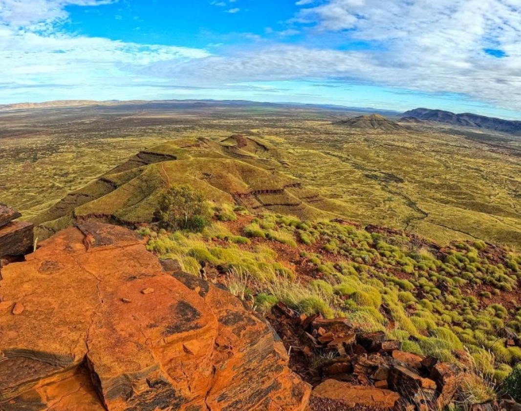
Skip to Content Skip to Navigation Show Trail Map Show About the Trail Show Important Trail Details Read Trail Reviews
Support Our Trails

Mt Bruce Summit, Karijini NP Mt Bruce Summit, Karijini NP

  • Half day
  • 9 km
    • Bush Walk Class 5

      Extreme trail with very rough surface, and may have very steep hills, arduous rock hopping or rock scrambling. Limited or no directional signage. For very experienced bushwalkers with navigation and emergency first aid skills, and high level of fitness.

The 9km return Mount Bruce Summit Trail is located in the Karijini National Park and allows great opportunities to view the surrounding Hamersley Range and Marandoo mining operations.
This Grade 5 moderately steep trail follows a clearly marked path along the ridge of the mountain with a couple of challenging rocky climbs to negotiate.

The trail follows the western ridge of the mountain to the summit
Earn 3 Points Tall Peak
Logo for Leave no Trace Initiative

Trails WA supports the seven principles recommended by Leave No Trace Australia for minimising your impacts when using the trails.

Learn more

The first section of the trail to Marandoo View, where you can see down into the Marandoo iron ore mining operations is fairly easy, but from this point on the trail steepens and becomes a steady climb along the ridge to the summit.

At about 2.3km into the walk and after negotiating an incline littered with large slabs of rock the trails steepens and forms a series of switchbacks before being faced with a nearly verticle climb. A chain attached to the rock face provides some assistance along a narrow ledge and the naturally forming large rectangular boulders provide an abundance of hand and footholds.

After a few more scrambles over scattered boulders and some fairly easy trail, you are at the summit, with panoramic views of the surrounding Hamersley Ranges

Mt Bruce or Punurrunha, as is is known to the aboriginal people, is the second highest peak in Western Australia, at 1249 metres high.

June to August are the best times of year to tackle this climb when the day time temperatures are in the low to mid 20s. Avoid climbing during the hotter months when temperatures soar to 40 degrees or more. Remember your sun hat, carry plenty of water and bring a cameral to capture the amazing scenery and views from the summit. 

Be trail ready for Mt Bruce Summit, Karijini NP

Here is everything you need to know before visiting this trail.

Time / Duration

6 hours return, depending on fitness level

Length

9 kilometres return from the car park to the summit

What To Pack

Group B (Bushwalks and/or longer trails) required.

Trail Start

The trail starts at the Mt Bruce carpark on Karijini Drive, Karijini NP, 1 hour east of Tom Price and 1,400km north of Perth

Get directions

Trail End

Get directions

Bush Walk

Class 5

Extreme trail with very rough surface, and may have very steep hills, arduous rock hopping or rock scrambling. Limited or no directional signage. For very experienced bushwalkers with navigation and emergency first aid skills, and high level of fitness.

Visit Trail Tips for further information.

Difficulty Notes

This walk is not for the faint-hearted. Some parts of walk trail are class 5 and require high level of fitness and experience.

Hazards & Warnings

Day time temperatures can reach 35 to 45 degrees between October and March. Hiking is not recommended

Facilities

Information Shelter
  • Car Park
  • Lookouts
  • Public Toilet
  • View Platform

Best time of year

May to August when the temperature is cooler.

Fees

National Park fees apply

Trail Access

Air or road to Tom Price, self drive to Karijini NP 2WD and large vehicle accessible

Prohibited Items

No pets or fires are permitted in the National Park
Edge shaped like mountain horizon
topography pattern

Complete Mt Bruce Summit, Karijini NP to earn badges and points!

Earn points and badges and become a "TrailsWA Expert" by completing trails and leaving reviews.

Earn 3 Points

Earn 3 points towards
your TrailsWA level

Tall Peak

Earn the Tall Peak badge when you complete this trail.

Edge shaped like mountain horizon
Alt text

5 trail goers have rated Mt Bruce Summit, Karijini NP as 5 out of 5!

We love to hear from people who've been on our Western Australian trails, so it would be most appreciated it if you wanted to leave a review.

Luke Toledo

Reviewed 2 Apr 2023, 10:44am

Easily one of the best trails. The scrambles feel quite dangerous at first, but upon completion are actually quite easy. Rest of the trail is just loose and steep in sections. Nice views, only ruined by Marandoo Mine to the South.

Completed very early morning in Mid-September, was very breezy which kept temps (and flies) down, but it was definitely getting quite warm by 9am.

Would not recommend others attempt at this time of year, if not acclimated to Pilbara conditions.
Mags Min

Reviewed 28 Jun 2021, 12:55pm

Great trail. Great views. Went for time on this one. From car park to summit and back to car park was 1hr 35 mins and 34 secs. Did it today, 28th of June 2021. Left just before midday and was back at carpark for lunch. Some clouds and a light breeze so it wasn't so hot. Definitely couldn't have done this time in summer months. I have it recorded it on suunto ambit and on my phone. Took plenty of photos and videos on the way too. Could probably knock another 10 or so minutes off. Anyone know what the time record for this ascent and descent is? Enjoy ????
Emma Williams

Reviewed 21 Apr 2020, 2:18pm

I completed the hike in October 2019 and it is the most challenging day hike I have completed in WA. We started at 6am and it took us 4hrs to complete. At 6am it was already quite warm and I would not recommend starting any later. If I was to do the hike again, I would start earlier with the sun rise. The hike is beautiful, well marked and the terrain does change throughout the trail. Some parts of the trail are very steep and rocky and there is no shade on the trail. We passed some people on the trail who were struggling and had not brought enough water. It is a tough climb and I would recommend a high level of fitness, 3litres of water and starting as early as possible. If you don't think you would be able to complete the walk there is a lookout a short way into the trail that is easily accessible and offers nice views.
Peter Harrison

Reviewed 1 May 2018, 1:50pm

What a wonderful, sacred place and a great climb. Definitely do this one again given the opportunity, a good challenge but not to be taken lightly or without respect, care does need to be taken, very worth the effort to the summit though.
Lee lee

Reviewed 22 Apr 2017, 5:07pm

A trail to conquer, this one is a good challenge in the way of trails in Western Australia. Its well marked and does change to a more difficult level where hikers will need to scramble up the rock in a number of spots as well as trace a rockface with a visible drop to the side. Care needs to be taken. Views are amazing across the Pilbara landscape and you don't need to complete the hike to the summit to access the views. The first section of the trail would be good for a family with bush walking experience. Do early morning for a beautiful sun rise experience.

Supported by great organisations

Trails are free and bring so many benefits to our community by providing opportunities to have fun, get fit, socialise, explore and challenge yourself. But they also have to be managed and maintained which only is made possible through terrific sponsors, donations and/or volunteering.

topography pattern