Difficult trail with rough surface that may have very steep hills or extensive rock hopping. Directional signage may be limited. Bushwalking experience, navigation and emergency first aid skills, and good fitness required.
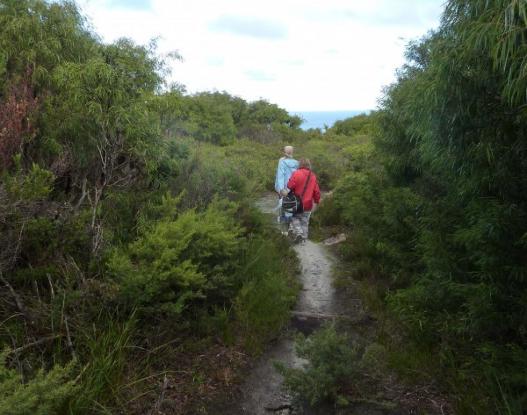
Peak Head Track is in the spectacular Torndirrup National Park near Albany. The almost five kilometre return walk follows a sandy track that winds through thick coastal scrub and granite walls. You are rewarded for your efforts by spectacular views of the Southern Ocean.
At the southernmost peak of the Torndirrup Peninsula is Peak Head, a bluff of rounded cliffs with spectacular ocean views.
The track to Peak Head starts near the Stony Hill carpark and winds through thick coastal scrub. The return walk takes around 2.5 hours and requires some clambering and climbing over granite rocks and up small granite walls.
Fantastic views over the Southern Ocean make the effort worthwhile.
Difficult trail with rough surface that may have very steep hills or extensive rock hopping. Directional signage may be limited. Bushwalking experience, navigation and emergency first aid skills, and good fitness required.
There is some scrambling and climbing over granite along this walk.
Hazards & Warnings
The weather on the south coast can change quickly. Be prepared with appropriate clothing and carry drinking water. The southern ocean can be unpredictable. Do not try to reach the water. Lives have been lost
Complete Peak Head Track, Torndirrup National Park to earn badges and points!
Earn points and badges and become a "TrailsWA Expert" by completing trails and leaving reviews.
Earn 3 points towards your TrailsWA level
4 trail goers have rated Peak Head Track, Torndirrup National Park as 4.25 out of 5!
We love to hear from people who've been on our Western Australian trails, so it would be most appreciated it if you wanted to leave a review.
Add your review of Peak Head Track, Torndirrup National Park
james bolst rated Peak Head Track, Torndirrup National Park a 4 out of 5
james bolst
Reviewed 2 Apr 2023, 10:51pm
The trail is really steep in places! Some of the steps are getting worn. The trail has also been weathered in places where the rain has flowed down the trail. To find the actual peak is not marked so you will have to find your way!! It's good fun. The rocks would be very slippery in winter after rain so be careful. I just completed it today and the weather was perfect!
Jazmin Maher rated Peak Head Track, Torndirrup National Park a 4 out of 5
Jazmin Maher
Reviewed 27 Jan 2023, 10:02am
Towards the peak, the signage is very limited. Look for the rock towers that previous walkers have made. Otherwise, a decent hike. Not for the beginner hiker as it requires a certain amount of fitness to get through the sand and granite outcrops.
Chelle Fisher rated Peak Head Track, Torndirrup National Park a 5 out of 5
Chelle Fisher
Reviewed 1 Jun 2022, 7:21pm
Fantastic trail. Awe inspiring views and a great challenge.
Gaelia Hunt rated Peak Head Track, Torndirrup National Park a 4 out of 5
Gaelia Hunt
Reviewed 6 Jan 2022, 2:08pm
Absolutely stunning scenery
However trail is not 4.8km. We did 5.8 and didn't even reach the final peak as couldn't find a path through the last bit of bush after the first level of rock near the summit.
Very glad I had walking poles.
Trails are free and bring so many benefits to our community by providing opportunities to have fun, get fit, socialise, explore and challenge yourself. But they also have to be managed and maintained which only is made possible through terrific sponsors, donations and/or volunteering.
DPaW
On the trail to Peak head
DPaW
Peak Head
Carry water and food and be prepared for changing weather
DPaW
Peak Head Trail
Be prepared for scrambling over rock outcrops
DPaW
Peak Head Trail
There are some small climbs/scrambles to reach the headland
Chelle Fisher - ReWildWA
Peak Head Trail
Peak Head Trail
View 5 Photos
of Peak Head Track, Torndirrup National Park
Upload your photo of Peak Head Track, Torndirrup National Park
Report a Problem
You are reporting a problem for Peak Head Track, Torndirrup National Park. Please be as detailed as possible to help us appropriately identify and address the issue.
Please sign in or join up
Join Trails WA
Join trails wa to add this trail to your favourite. By joining you will also be able to rate and review trails and share your photos with other trail goers!