Manning Gorge, Mount Barnett Station, Kimberley Manning Gorge, Mount Barnett Station, Kimberley



Trails WA supports the seven principles recommended by Leave No Trace Australia for minimising your impacts when using the trails.
Learn moreAbout Manning Gorge, Mount Barnett Station, Kimberley
Manning Gorge is located on Mount Barnett Station, about half way along the Gibb River Road. Access is via the Mt. Barnett Roadhouse.
The roadhouse is really well equipped, well set up and offers good service. This is also where you pay your entrance and camping fee for Manning Gorge.
(You pay that first, and then you drive on for about 7 kilometres to the camping area and gorge.)
The 5.6km return trail starts at the Manning Gorge Campsite. The trailhead is right on the Manning River and you have to cross it, swimming, wading or both. When we did it in 2017 you could drag yourself across using a rope pulley system and a dinghy. It adds a bit of adventurous fun to the walk.
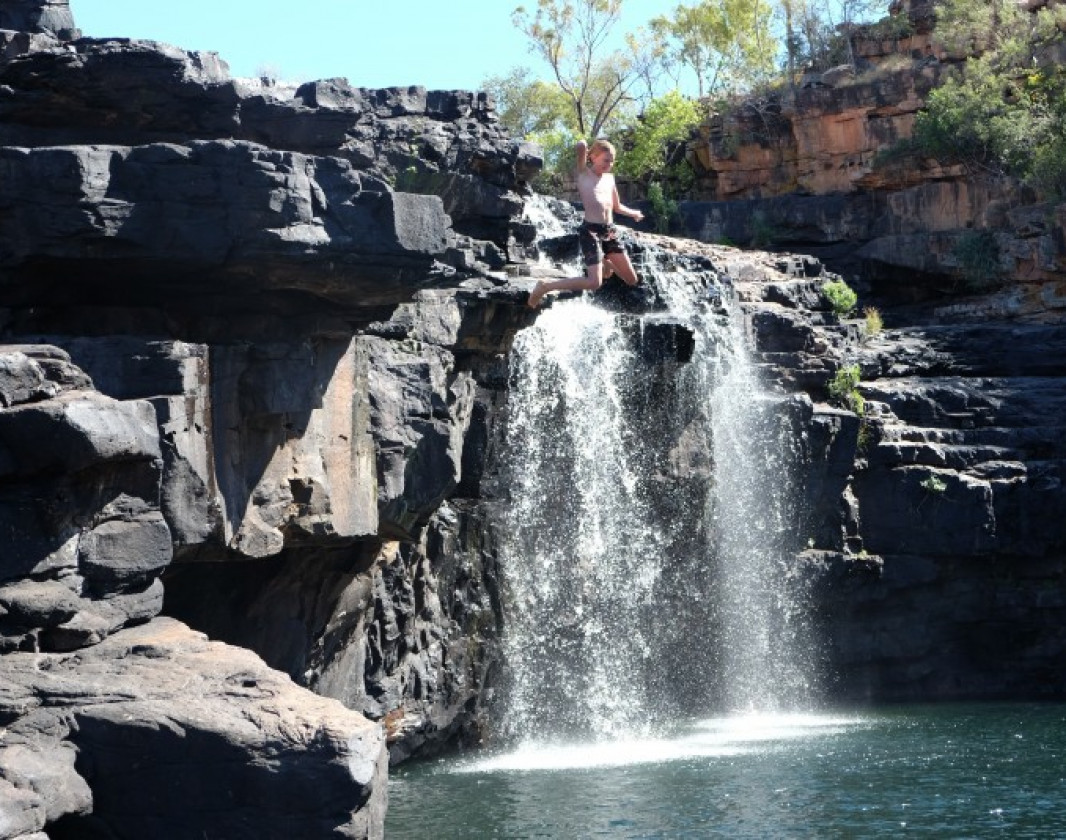
The well-marked trail starts for earnest on the other side of the river. Along the way are views to the ranges and savannah woodlands, culminating in a massive gorge with a huge waterfall fed pool. It is one of the best swimming spots in the Kimberley.
The gorge itself is huge and you can easily spend hours exploring it. It has several pools to swim through and rocks to climb up and over. You can also climb to the top of the waterfall.
The trail goes through uneven, rocky terrain getting progressively harder near the end. Most people of reasonable fitness should do the Grade 4 trail without big problems. Be sure you take plenty of drinking water and don’t leave too late in the afternoon to avoid being caught in the dark.
Mount Barnett Station
(08) 9191 7007
Be trail ready for Manning Gorge, Mount Barnett Station, Kimberley
Here is everything you need to know before visiting this trail.
Time / Duration
2 hours plus swim time
Length
5.6km return
What To Pack
Group B - Hiking & Long Distance Trails (Bushwalks and/or longer trails) required.
What To Pack
Group B - Hiking & Long Distance Trails (Bushwalks and/or longer trails)
- Sun protection: hat, sunglasses, and sunscreen (SPF 30+)
- Insect repellent
- Plenty of drinking water (as a minimum carry and drink 1 litre of water per hour of walking, per person).
- PLB or satellite phone
- Clothing to suit the activity, environment and weather conditions.
- Map/ Compass, do not rely on your phone in remote locations.
- Snacks/ Meals to keep your energy levels up on longer walks
- Extra food and water in case of unexpected delays
- Rubbish bag to remove all your rubbish
- Reference material such as wildflower wildlife guides.
- Whistle (for emergencies, six short blasts per minute)
- Small trowel for toilet emergencies, and a few sheets of toilet paper in a small waterproof bag.
- Personal first aid kit (check that items are clean, properly sealed, have not exceeded expiry dates and that used items have been replaced).
- Torch/ Headlamp
- Binoculars and camera (optional)

Bush Walk
Class 4
Difficult trail with rough surface that may have very steep hills or extensive rock hopping. Directional signage may be limited. Bushwalking experience, navigation and emergency first aid skills, and good fitness required.
Visit Trail Tips for further information.
Difficulty Notes
Rock hopping into the gorge
Facilities
- Camping
- Car Park
Best time of year
May to October. The dry season in the Kimberley
Fees
Camping fees at Mt Barnett Station
Trail Access
Air, Drive or Bus to Broome. 4WD to Mount Barnett 420km east of Broome. See Group D items on Trail Tips page.


Complete Manning Gorge, Mount Barnett Station, Kimberley to earn badges and points!
Earn points and badges and become a "TrailsWA Expert" by completing trails and leaving reviews.
Earn 2 points towards
your TrailsWA level
Earn the Gorges badge when you complete this trail.


Be the first to review Manning Gorge, Mount Barnett Station, Kimberley
We love to hear from people who've been on our Western Australian trails, so it would be most appreciated it if you wanted to leave a review.
Add your review of Manning Gorge, Mount Barnett Station, Kimberley
Like this trail? Explore others nearby
More around North West
 Less than 1 hour
 1.2km
1.2km


Closed temporarily

Seasonal Closure
-crop-340x230.jpg)
Supported by great organisations
Trails are free and bring so many benefits to our community by providing opportunities to have fun, get fit, socialise, explore and challenge yourself. But they also have to be managed and maintained which only is made possible through terrific sponsors, donations and/or volunteering.
-(1680-×-200-px).jpeg)


Manning Falls
The falls flow year round into Manning Gorge. Great swimming
Trail to Manning Gorge
There are lots of trail markers on the way to Manning Gorge
Manning Gorge trailhead
The start of the trail to Manning Gorge
Crossing the Manning Creek
A small dinghy is used to cross the river using ropes that you pull yourself across with
Walking to Manning Gorge
The walk is mostly flat but does climb in and out of 3 creeks on the way
Aboriginal paintings at Manning Gorge
Aboriginal paintings at Manning GorgeView 6 Photos of Manning Gorge, Mount Barnett Station, Kimberley
Upload your photo of Manning Gorge, Mount Barnett Station, Kimberley
Report a Problem
You are reporting a problem for Manning Gorge, Mount Barnett Station, Kimberley. Please be as detailed as possible to help us appropriately identify and address the issue.