

Honey Hakea Track, Karijini National Park Honey Hakea Track, Karijini National Park


Trails WA supports the seven principles recommended by Leave No Trace Australia for minimising your impacts when using the trails.
Learn moreAbout Honey Hakea Track, Karijini National Park
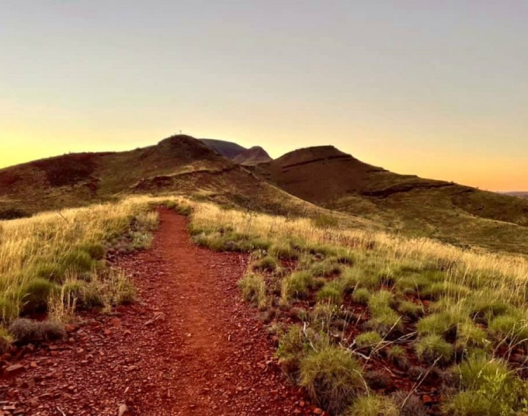
The Honey Hakea Track is a fantastic alternative for those who do not feel confident to tackle the Grade 5 Mt Bruce Summit Trail.
Leaving from the Mt Bruce car park the trail takes you past Marandoo View where you can see down into the workings of the Marandoo iron ore mine, before continuing on up the ridge of Mt Bruce. The trail steadily climbs uphill and is clearly marked.
There is a second vantage point at the end of the Honey Hakea Track with stunning views of the the Mt Bruce summit and surrounding hills. From here on the Mt Bruce Summit Trail gets increasing steep and more difficult.
Mt Bruce is known as Punurrunha to the local aboriginal people.
The best months to hike this trail are May to August when the temperature is cooler. Remember your hat and plenty of drining water before heading out.
Other Links
-
Department of Biodiversity, Conservation and Attractions, Parks and Wildlife Service
Mt Bruce and the Honey Hakea Track
Downloads
Be trail ready for Honey Hakea Track, Karijini National Park
Here is everything you need to know before visiting this trail.
Time / Duration
3.5 hours
Length
4.6 km return
What To Pack
Group B - Hiking & Long Distance Trails (Bushwalks and/or longer trails) required.
What To Pack
Group B - Hiking & Long Distance Trails (Bushwalks and/or longer trails)
- Sun protection: hat, sunglasses, and sunscreen (SPF 30+)
- Insect repellent
- Plenty of drinking water (as a minimum carry and drink 1 litre of water per hour of walking, per person).
- PLB or satellite phone
- Clothing to suit the activity, environment and weather conditions.
- Map/ Compass, do not rely on your phone in remote locations.
- Snacks/ Meals to keep your energy levels up on longer walks
- Extra food and water in case of unexpected delays
- Rubbish bag to remove all your rubbish
- Reference material such as wildflower wildlife guides.
- Whistle (for emergencies, six short blasts per minute)
- Small trowel for toilet emergencies, and a few sheets of toilet paper in a small waterproof bag.
- Personal first aid kit (check that items are clean, properly sealed, have not exceeded expiry dates and that used items have been replaced).
- Torch/ Headlamp
- Binoculars and camera (optional)
Additional Useful Items
Take plenty of drinking water and sun protection. Please remember Karijini National Park's climate can be best described as tropical semi-desert, and hence temperatures in summer are frequently topping 40 degrees celsius.Trail Start
The trail starts at the Mt Bruce carpark on Karijini Drive, Karijini NP, 1 hour east of Tom Price and 1,400km north of Perth
Trail End

Bush Walk
Class 3
Moderate trail that may have short steep hills, rough surface, many steps or some rock hopping. Directional signage. Some bushwalking experience and moderate fitness required.
Visit Trail Tips for further information.
Hazards & Warnings
Day time temperatures can reach 35 to 45 degrees between October and March. Hiking is not recommendedFacilities
Information shelter- Car Park
- Lookouts
- Public Toilet
- View Platform
Best time of year
May to August when the temperature is cooler.
Fees
National Park fees apply
Trail Access
Air or road to Tom Price, self drive to Karijini NP 2WD and large vehicle accessible
Prohibited Items
No pets or fires are permitted in the National Park

Complete Honey Hakea Track, Karijini National Park to earn badges and points!
Earn points and badges and become a "TrailsWA Expert" by completing trails and leaving reviews.
Earn 2 points towards
your TrailsWA level
Earn the Wildflower Wanderer badge when you complete this trail.


Be the first to review Honey Hakea Track, Karijini National Park
We love to hear from people who've been on our Western Australian trails, so it would be most appreciated it if you wanted to leave a review.
Add your review of Honey Hakea Track, Karijini National Park
Like this trail? Explore others nearby
More around North West


Circular Pool Trail is closed until further notice due to rockfalls in the area.
To check the most

Gorge Rim Walk and Dales Gorge Trail, Karijini NP
-
 Half day
-
5.1km

Supported by great organisations
Trails are free and bring so many benefits to our community by providing opportunities to have fun, get fit, socialise, explore and challenge yourself. But they also have to be managed and maintained which only is made possible through terrific sponsors, donations and/or volunteering.


Sunrise over Mt Bruce

Honey Hakea Track

Mt Bruce
The Honey Hakea Track starts at the base of Mt BruceView 3 Photos of Honey Hakea Track, Karijini National Park
Upload your photo of Honey Hakea Track, Karijini National Park
Report a Problem
You are reporting a problem for Honey Hakea Track, Karijini National Park. Please be as detailed as possible to help us appropriately identify and address the issue.
