

Flowtopia, Goat Farm Mountain Bike Trail Flowtopia, Goat Farm Mountain Bike Trail
Part of
Goat Farm Mountain Bike Park, Greenmount
network


Trails WA supports the seven principles recommended by Leave No Trace Australia for minimising your impacts when using the trails.
Learn moreAbout Flowtopia, Goat Farm Mountain Bike Trail
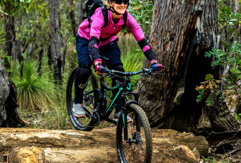
Freeride descent. This trail is all about having fun while developing skills. Riders are encouraged to extend the motion of the trail.
The Goat Farm Mountain Bike Park contains over 20km of mountain bike trails and a dedicated Skills Park with skills and jump areas. The Goat Farm trails range from Easy (Green) to Extreme (Double Black) and include four trails suitable for adaptive cyclists.
Visitor Information Centres
Other Links
- Goat Farmers MTB Park action group
- Westcycle
- Perth Mountain Bike Club
- DBCA Park Alerts - latest info' on trail closures
- Break The Boundaries
-
Destination Perth
Comprehensive information on the Perth region including destinations, things to see and do, accommodation and tours.
Be trail ready for Flowtopia, Goat Farm Mountain Bike Trail
Here is everything you need to know before visiting this trail.
Time / Duration
Up to 20minutes
Length
1.1km
What To Pack
Group C - Mountain Biking & Gravel (Mountain bike, gravel and touring trails.) required.
What To Pack
Group C - Mountain Biking & Gravel (Mountain bike, gravel and touring trails.)
- Always ride with a buddy and ride within your skill level
- Bike tools and spares (E.g. Mini bike-pump, spare tubes, puncture repair kit)
- Helmet, consider a full-face helmet for more difficult trails
- Water
- Snacks/ food
- Sun protection: sunglasses and sunscreen (SPF 30+)
- Additional protective gear: gloves, body armour
- For remote trails consider a PLB (Personal Locator Beacon) or satellite phone
- For longer trails take extra food and water
- Always have a first aid kit (vehicle nearby or on you for longer trails) and check that items are clean, properly sealed, have not exceeded expiry dates and that used items have been replaced
- Extra food and water in case of unexpected delays
Additional Useful Items
No water available in park.Trail Start
From the carpark/main trailhead, take either Wi-Fly or Bleat Street to access the top of the hill where this epic ride begins.
Trail End
At the end of the trail you merge onto Bada Mandoo trail which returns toward the main trailhead and car park.

Mountain Bike
Moderate
Recommended for moderate intermediate riders with some technical mountain biking experience. Typically narrow trails with loose, soft, rocky or slippery sections and hills with short steep sections. Riders will encounter obstacles and technical trail features.
Visit Trail Tips for further information.
Difficulty Notes
Moderate (Blue): Recommended for intermediate riders with some technical skills. Narrow trail that may have loose, soft, rocky or slippery sections and hills with short, steep sections. Riders will encounter obstacles and technical trail features.
Hazards & Warnings
Summer months (December to April) can be extremely hot. Carry a full water bottle. Trail has a natural surface and may include granite and rock so caution is advised.
Safety
In case of an emergency on the trail, always carry a mobile phone and basic first aid supplies. The nearest hospital is St John of God Midland Public Hospital.
Facilities
The main trailhead is adjacent to the car park. Trailhead facilities include toilets, picnic tables, an information shelter and shaded areas to take a break between rides. There are also picnic tables in the shade at the upper trailhead near to where this trail starts.
- Bicycle Rack
- Public Toilet
- Shaded Area
- Sheltered Area
- Car Park
- Picnic Area
Best time of year
mid April to October
Trail Access
Road, Train Bus or Ride
Prohibited Items
Dogs on leads are permitted at the main Trailhead


Complete Flowtopia, Goat Farm Mountain Bike Trail to earn badges and points!
Earn points and badges and become a "TrailsWA Expert" by completing trails and leaving reviews.
Earn 2 points towards
your TrailsWA level
Earn the Mountain Biker badge when you complete this trail.


Be the first to review Flowtopia, Goat Farm Mountain Bike Trail
We love to hear from people who've been on our Western Australian trails, so it would be most appreciated it if you wanted to leave a review.
Add your review of Flowtopia, Goat Farm Mountain Bike Trail
Like this trail? Explore others nearby
More around Perth & Surrounds


Supported by great organisations
Trails are free and bring so many benefits to our community by providing opportunities to have fun, get fit, socialise, explore and challenge yourself. But they also have to be managed and maintained which only is made possible through terrific sponsors, donations and/or volunteering.


Flowtopia
View 1 Photos of Flowtopia, Goat Farm Mountain Bike Trail
Upload your photo of Flowtopia, Goat Farm Mountain Bike Trail
Report a Problem
You are reporting a problem for Flowtopia, Goat Farm Mountain Bike Trail. Please be as detailed as possible to help us appropriately identify and address the issue.
