Skip to Content Skip to Navigation Show Trail Map Show About the Trail Show Important Trail Details Read Trail Reviews

Your bookings

Escarpment Trail, Kennedy Range NP

Mundatharrda, Yingarrda Country

The Kennedy Range is known as Mundatharrda to the Yingarrda people, who are the Traditional Custodians of the area.

Part of Kennedy Range National Park network

Trail difficulty
Trail difficulty
  • Length 3.4km
  • Est. time Half day
  • Return
Today

25°C

25°

13°

Part of Kennedy Range National Park network

Earn badges and points by completing this trail.

Earn 3 Points

Trails WA supports the seven principles recommended by Leave No Trace Australia for minimising your impacts when using the trails.

Learn more

Read more about this trail

To avoid unnecessary difficulty, don’t start this trail late in the day. Although it’s only 3.4 kilometres, it typically takes 2–3 hours and finishing in the dark would is far from ideal in terms of safety.

The marked track begins along a rocky creek bed, leading into a narrow gorge. The route gradually becomes steeper, with loose rocks and exposed cliff edges, so careful footing is essential. For the easiest navigation, keep an eye out for the next trail marker at all times - carry a map and know how to use it.

After a steady climb, you’ll reach the top. From there, turn left and follow a more defined path across flat terrain to a lookout offering spectacular panoramic views.

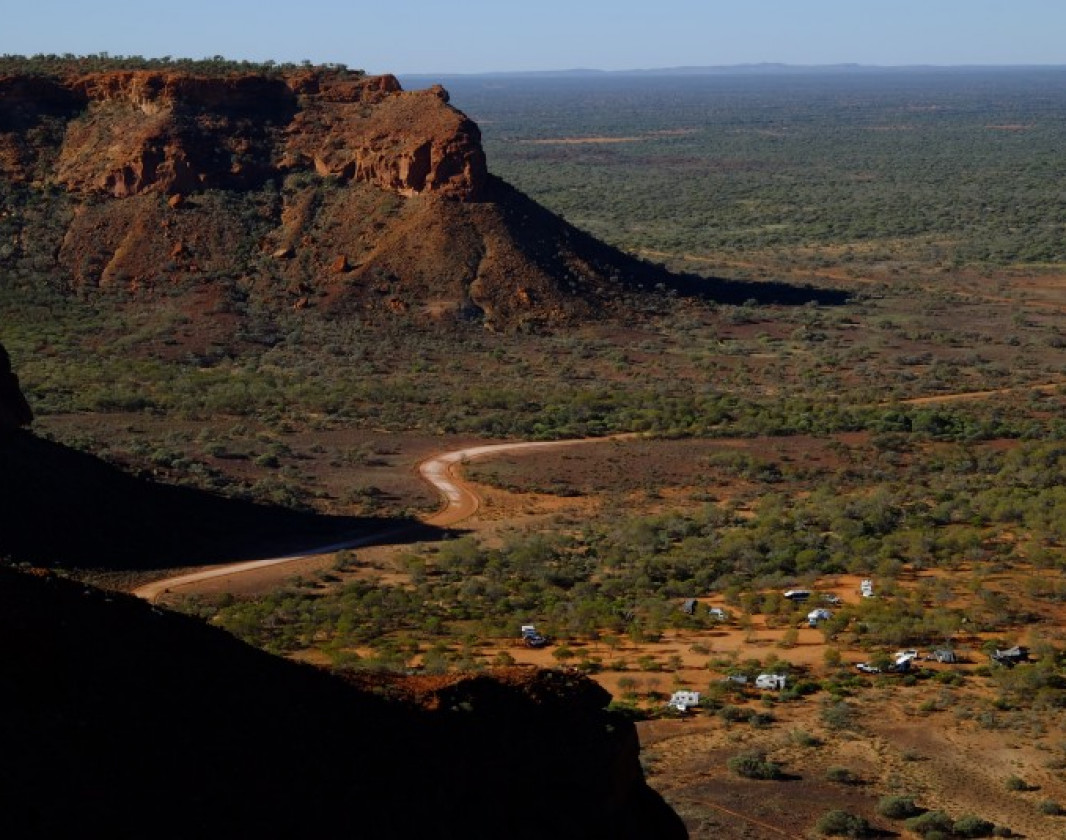
From the lookout, you can see Temple Gorge campground far below, where caravans and camper trailers appear tiny against the vast landscape. The view showcases dramatic cliff faces and escarpments stretching out over the plains.

Keep in mind that the descent can be just as demanding as the climb. Walking poles are highly recommended to help manage the steep and uneven terrain on the way down.

National Parks

Other Links

  • Australia’s Coral Coast

    Comprehensive information on the Coral Coast region including destinations, things to see and do, accommodation and tours.


Expand your trip Browse and book with great businesses nearby.

With many businesses in the local area, planning your trip has never been easier.

Want your business featured here?

We’re always looking to support local businesses and enrich the trailgoer experience.

Be trail ready

Here is everything you need to know before visiting this trail.

Time / Duration

3 hours return

Length

3.4 kilometres return

Trail Access

Road, 2WD gravel road, check road conditions with the Carnarvon Shire

Trail Start

Either Drapers or Temple Gorge carpark, Kennedy Range NP, 150km from Carnarvon which is 900km (9.5hours) north of Perth

Get directions

Trail End

End at either Drapers or Temple Gorge Carparks

Get directions

When to go

May to November. Walking is not recommended from December to March when temperatures can exceed 40 degrees Celsius

What’s the weather like?

Bush Walk

Class 4

Difficult trail with rough surface that may have very steep hills or extensive rock hopping. Directional signage may be limited. Bushwalking experience, navigation and emergency first aid skills, and good fitness required.

What To Pack

Hazards & Warnings

Avoid hiking in hot weather; the risks from exposure and dehydration are significant in this area - the best months are May to August. Radiant heat from the rocky terrain increases temperatures by 5-10 degrees Celsius. Hike during the coolest times of day.

Prohibited items

No pets permitted

Safety

Carry and drink 3 to 4 litres of water per person per day. There is no drinking water in the park.

Wear a broad brimmed hat, loose clothing, long sleeves and sunscreen to minimise heat stress and burn.

Wear sturdy footwear.

Carry a Personal Locator Beacon (PBL) in case of emergency.


Facilities

Temple Gorge campground is a bush campsite. Camping fees apply. Toilets are provided but there is no water available. To assist visitors, Parks and Wildlife Campground Hosts are usually based at the campground from May to September.

There is a ‘communal’ fireplace at the Temple Gorge campground. To protect wildlife habitat and the ecology of the national park, please collect wood before getting to the park. Collecting wood in the park is not permitted and personal campfires are strongly discouraged.

Accommodation is available at Gascoyne Junction (Junction Pub and Tourist Park) 

  • Camping
  • Car Park
  • Public Toilet

Trail information updated
21st July 2026

Today Jul 22, 4:06pm

25°C

Feels like 24°C

Max 25°

Min 13°

Precipitation: 0%

Visibility: 10km

Wind: 5.08km/h SE

Weather data provided by:

Complete this trail to earn badges and points!

Earn points and badges and become a "TrailsWA Expert" by completing trails and leaving reviews.

Earn 3 Points

Earn 3 points towards
your TrailsWA level

1 trail goers have rated this trail as 5 out of 5!

We love to hear from people who've been on our Western Australian trails, so it would be most appreciated it if you wanted to leave a review.

Peter Harrison

Reviewed 1 May 2018, 2:24pm

This place is a real surprise, amazing to say the least, The escarpment trail early morning gives some breathtaking views with the sun shining through the trail up to the escarpment. Was there mid April 2018, only downside are the number of flies, mixed in with the heat and dust!

Like this trail? Explore others nearby

More around Coral Coast

Supporters & Partners

Trails are free and offer countless benefits to our community, from fostering fun and fitness to encouraging social connection, exploration, and personal challenges. These exceptional trail experiences are made possible through the support and collaboration of these great organisations and initiatives: