Extreme trail with very rough surface, and may have very steep hills, arduous rock hopping or rock scrambling. Limited or no directional signage. For very experienced bushwalkers with navigation and emergency first aid skills, and high level of fitness.
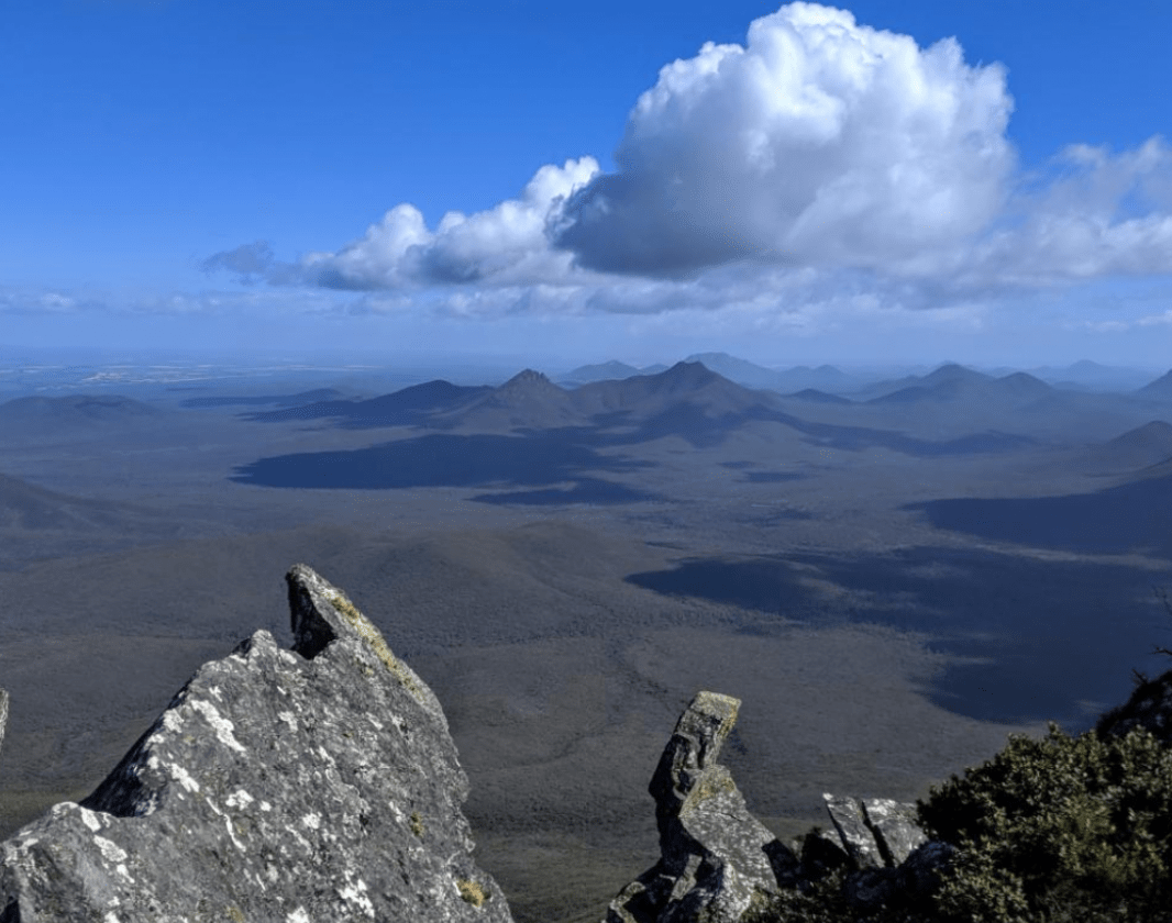
Enjoy magnificent views from the summit of Mt Toolbrunup, the second highest peak in the Stirling Range. A good degree of fitness is required for this four kilometre return hike.
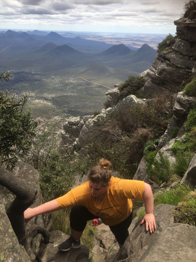
Toolbrunup Peak towers above the other western peaks and offers uninterrupted views in all directions but can only be reached if you are fit and agile and prepared to scramble up some steep rock sections.
The trail leaves the carpark and leads through woodland, mostly following the bank of a creek and becoming progressively steeper. Beyond the woodland it rises steeply over large boulders, loose rocks and steep scree to a saddle near the top of the south-west buttress.
From here it’s a short, steep scramble to the top. During spring, those who reach the upper slopes will be rewarded with beautiful mountain bells and southern cross flowers.
Be trail ready for Mt Toolbrunup, Stirling Range NP
Here is everything you need to know before visiting this trail.
Time / Duration
3 - 4 hours return
Length
4km return
What To Pack
Group B - Hiking & Long Distance Trails
(Bushwalks and/or longer trails)
required.
What To Pack
Group B - Hiking & Long Distance Trails
(Bushwalks and/or longer trails)
Sun protection: hat, sunglasses, and sunscreen (SPF 30+)
Insect repellent
Plenty of drinking water (as a minimum carry and drink 1 litre of water per hour of walking, per person).
PLB or satellite phone
Clothing to suit the activity, environment and weather conditions.
Map/ Compass, do not rely on your phone in remote locations.
Snacks/ Meals to keep your energy levels up on longer walks
Extra food and water in case of unexpected delays
Rubbish bag to remove all your rubbish
Reference material such as wildflower wildlife guides.
Whistle (for emergencies, six short blasts per minute)
Small trowel for toilet emergencies, and a few sheets of toilet paper in a small waterproof bag.
Personal first aid kit (check that items are clean, properly sealed, have not exceeded expiry dates and that used items have been replaced).
Torch/ Headlamp
Binoculars and camera (optional)
Additional Useful Items
Walk safely. All walks in the Stirling Range are steep and have uneven surfaces. Wear boots or sturdy footwear, weatherproof clothing and sun protection. Take plenty of food and carry two to three litres of drinking water per person for half to full day walks.
Please take all your rubbish out with you.
Extreme trail with very rough surface, and may have very steep hills, arduous rock hopping or rock scrambling. Limited or no directional signage. For very experienced bushwalkers with navigation and emergency first aid skills, and high level of fitness.
Complete Mt Toolbrunup, Stirling Range NP to earn badges and points!
Earn points and badges and become a "TrailsWA Expert" by completing trails and leaving reviews.
Earn 2 points towards your TrailsWA level
Earn the
Tall Peak
badge when you complete this trail.
This trail is part of the
Stirling Range Peaks
badge.
8 trail goers have rated Mt Toolbrunup, Stirling Range NP as 4.88 out of 5!
We love to hear from people who've been on our Western Australian trails, so it would be most appreciated it if you wanted to leave a review.
Add your review of Mt Toolbrunup, Stirling Range NP
Sue Morgan rated Mt Toolbrunup, Stirling Range NP a 4 out of 5
Sue Morgan
Reviewed 18 Jan 2023, 6:53am
As a moderately fit and active middle aged woman, I found this a very challenging hike. Partly because it's steep, but mainly because the majority of the hike is on either loose rocks or large boulders which require hands on scrambling or climbing. Going up requires cardio fitness, coming down requires youthful knees and joints! Both directions require concentration and good footwear. Definitely worth doing for the incredible views, but not for the faint-hearted! One request is that a long drop toilet be installed in the car park, as people aren't following bush toilet etiquette. It's clear that everyone uses the bush near the car park by the disgusting litter of soiled toilet paper lying around. This detracted somewhat from the beauty of the area.
Chelle Fisher rated Mt Toolbrunup, Stirling Range NP a 5 out of 5
Chelle Fisher
Reviewed 7 Sep 2022, 9:39am
I can't believe I put off this hike for as long as I did. Definitely overthought it going by others blogs and whilst it is what I feel the most technically challenging hike in the Stirling Range, I did really enjoy it. Pretty hard going on the knees on the way down though so pulled up a little sore but had picture perfect weather so I couldn't ask for a more perfect mountain experience.
Jenny Caldwell rated Mt Toolbrunup, Stirling Range NP a 5 out of 5
Jenny Caldwell
Reviewed 29 Jun 2022, 9:17am
Loved it! The weather wasn't the best with cloud cover, heavy mist and rain. It settled and I managed to get sneak peaks off the amazing views. I can't wait to do it again!
Miss T rated Mt Toolbrunup, Stirling Range NP a 5 out of 5
Miss T
Reviewed 18 Jan 2021, 12:52pm
Rocky scramble almost all the way up. Not a "difficult" climb - but as much of it is over steep unstable rocks, it's tricky on your balance and your foot placement. Probably the first trek I've done where coming down took almost as long as going up.
Very awesome at the top - and like others say - it's rewarding. It's a totally different type of walk to Bluff Knoll, so I can't compare them. Def want your hiking boots for this one though!
Bob Peters rated Mt Toolbrunup, Stirling Range NP a 5 out of 5
Bob Peters
Reviewed 12 Feb 2020, 12:32pm
Excellent. Tough climb but more interesting than Bluff Knoll.
Petra Maxted rated Mt Toolbrunup, Stirling Range NP a 5 out of 5
Petra Maxted
Reviewed 14 Apr 2018, 8:13pm
We've been up and down Toolbrunnup quite a few times over the years. Whenever we have visitors from overseas we also take them up there.
The treck starts in beautiful woodland and then gradually turns more and more gravelly. About 2 thirds up is a whole section which just consists of big rock plates; and from there it's quite steep and narrow till the top.
We find Toolbrunup much more fun than Bluff Knoll but it is also harder because of the scramble towards the top - You probably shouldn't be too worried about heights if you make your way up there and, if these things make you overly nervous, I guess it's worth noting that there isn't too much room at the top with quite steep drops everywhere. The all round views are quite amazing.
Ashley Taylor rated Mt Toolbrunup, Stirling Range NP a 5 out of 5
Ashley Taylor
Reviewed 25 Dec 2017, 7:58pm
Amazing, easily the best in the Ranges.
Tom ALDAS rated Mt Toolbrunup, Stirling Range NP a 5 out of 5
Tom ALDAS
Reviewed 1 Jun 2017, 10:55pm
Incredible view, hard climb but well worth it. 380 degree views. Love this place better than Bluff Knoll.
You will not be disappointed.
Trails are free and bring so many benefits to our community by providing opportunities to have fun, get fit, socialise, explore and challenge yourself. But they also have to be managed and maintained which only is made possible through terrific sponsors, donations and/or volunteering.
Parks and Wildlife
Toolbrunup Peak
Parks and Wildlife
Toolbrunup Peak
Parks and Wildlife
Mt Toolbrunup
Pam Riordan
Mt Toolbrunup through the trees
Mt Toolbrunup through the trees
Pam Riordan
View from Toolbrunup
View from Toolbrunup
Chelle Fisher - ReWildWA
Toolbrunup Peak
Toolbrunup Peak
Fayley Arthur
Lari coming up to the summit
There are some final narrow steep scrambles to the summit
View 7 Photos
of Mt Toolbrunup, Stirling Range NP
Upload your photo of Mt Toolbrunup, Stirling Range NP
Report a Problem
You are reporting a problem for Mt Toolbrunup, Stirling Range NP. Please be as detailed as possible to help us appropriately identify and address the issue.
Please sign in or join up
Join Trails WA
Join trails wa to add this trail to your favourite. By joining you will also be able to rate and review trails and share your photos with other trail goers!