Skip to Content Skip to Navigation Show Trail Map Show About the Trail Show Important Trail Details Read Trail Reviews
Support Our Trails

Brigadoon Bridle Trails Brigadoon Bridle Trails

Equestrian  in Perth & Surrounds

(+7)
Avon Valley, Yanchep, Lancelin & Cervantes, Peel, Perth Hills, Perth Metro, Rottnest, Swan Valley

  • Full day
  • 54 km

The Brigadoon Trails are a series of trails linked together to form two larger loops accessible from several locations. These trails are quite challenging requiring a reasonably fit horse which has either shoes or boots. The going is at time steep and quite rocky in places. There are however, shorter sections such as along the river which are flat and suitable for an unshod horse.

Earn 3 Points Equestrian
Logo for Leave no Trace Initiative

Trails WA supports the seven principles recommended by Leave No Trace Australia for minimising your impacts when using the trails.

Learn more

The best place to park, provided the area is not being used for an event at the State Equestrian Centre (SEC), is round behind the SEC near the polo fields and the Swan Valley Pony Club. Toilets, yards water and wash bays are available here.  

From there you start the trail which runs along the east side (side closest to the SEC) of the creek adjacent to the fence line. The trail then veers right behind the Swan Valley Pony club and out onto the cross country course. You the need to look left to see a gate which you need to go through. This goes into the Riding for the Disabled (RDA) paddock area.

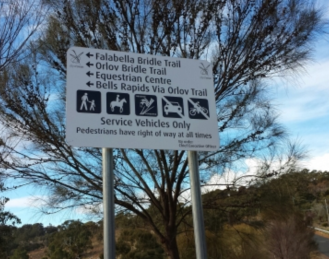
Follow the path towards the road where you will have to pass through another gate out onto Cathedral Ave. Cross the road and head across the open space towards the railway line and over the crossing you will see a sign for the Falabella Trail. Follow the trail, crossing Campersic Road further down and then on up the hill. When you reach the top of the hill, watch for another sign on your left which is where the Orlov Trail begins.

If you wish to take this loop back to the State Equestrian Centre, turn off here. This loop is easy to follow. It crosses back over Campersic Road after about 1 km, at which point there is another sign. You the travel down a rocky hill and at the bottom have to pass through a tunnel under the railway line. Once through the tunnel you are at Bells Rapids. There are toilet facilities available here if required.  

You will need to follow the road to the left and up the hill out of Bells Rapids. Unfortunately the trail has been completely washed out due to motor bike use in the winter, leaving no option but to ride on the road up the hill. Extreme care needs to be taken here as the road drops away on one side and cars are not always courteous to horses. Once at the top of the hill, follow the track to the right at the red and white boom gate, down to the river. Follow the track back along the river to where you have parked.

Should you choose to ride the Joshua Mews Trails, go past the Orlov Trail turn off to the top of the hill where the Falabella Trail meets Boulannais Dve. Turn right and ride along the road up the hill for about 1km. At the bottom of the next rise, watch carefully on the right for a sign for the Joshua Mews Trail. This is a loop trail with various access tracks out to the road making it possible to return to the SEC by road various ways or complete the loop and either the way you came or via the Orlov Trail.

Tips:
It should be noted that there is a lovely fresh water soak at the eastern end of the Joshua Mews Trail easily seen from the trail which has water year round. The sides are sheer so it is best to take a canvas bucket rather than risk letting your horse fall in the soak and not being able to get out.

If riding back to the SEC from Bells Rapids you will need to follow the road to the left and up the hill out of Bells Rapids. Unfortunately the trail has been completely washed out due to motor bike use in the winter, leaving no option but to ride on the road up the hill. Extreme care needs to be taken here as the road drops away on one side and cars are not always courteous to horses.

Swan Valley Visitor Centre

(08) 9207 8899

  • Visit website

Other Links

Be trail ready for Brigadoon Bridle Trails

Here is everything you need to know before visiting this trail.

Time / Duration

Time taken depends on which route is taken

Length

54km

What To Pack

Group H - Equestrian Trails (Equestrian and Horse Trekking trails) required.

Trail Start

State Equestrian Centre, 303 Cathedral Ave, Brigadoon. 30km (45 minutes) NE of Perth off Great Norther Hwy.

Get directions

Trail End

Difficulty Notes

Requires fit shod horse

Hazards & Warnings

These trails are quite challenging requiring a reasonably fit horse which has either shoes or boots. The going is at time steep and quite rocky in places.

Facilities

There is a lovely fresh water soak at the eastern end of the Joshua Mews Trail easily seen from the trail which has water year round. The sides are sheer so it is best to take a canvas bucket rather than risk letting your horse fall in the soak and not being able to get out.
  • Car Park
  • Public Toilet

Best time of year

March - November

Trail Access

Road

Edge shaped like mountain horizon
topography pattern

Complete Brigadoon Bridle Trails to earn badges and points!

Earn points and badges and become a "TrailsWA Expert" by completing trails and leaving reviews.

Earn 3 Points

Earn 3 points towards
your TrailsWA level

Equestrian

Earn the Equestrian badge when you complete this trail.

Edge shaped like mountain horizon
Alt text

1 trail goers have rated Brigadoon Bridle Trails as 5 out of 5!

We love to hear from people who've been on our Western Australian trails, so it would be most appreciated it if you wanted to leave a review.

Sue Forbes

Reviewed 27 Jan 2021, 8:45am

Very exciting trail in the hills with amazing views of Perth City and surrounding areas. We started on the Orlov Trail heading east out onto Caspian Way, a quiet road and back onto Boulonnais, we did not do the Joshua Mews Bushland, and went back onto Falabella Bridel Trail which all up was 12.5 km mostly walking, with a little bit of trotting and it took us 3 hours.

Like this trail? Explore others nearby

More around Perth & Surrounds

Supported by great organisations

Trails are free and bring so many benefits to our community by providing opportunities to have fun, get fit, socialise, explore and challenge yourself. But they also have to be managed and maintained which only is made possible through terrific sponsors, donations and/or volunteering.

topography pattern