Skip to Content Skip to Navigation Show Trail Map Show About the Trail Show Important Trail Details Read Trail Reviews
Support Our Trails

Bluff Knoll, Stirling Range NP Bluff Knoll, Stirling Range NP

  • Half day
  • 6.8 km
    • Bush Walk Class 4

      Difficult trail with rough surface that may have very steep hills or extensive rock hopping. Directional signage may be limited. Bushwalking experience, navigation and emergency first aid skills, and good fitness required.

Bluff Knoll is located in the Stirling Range National Park, 4.5 hours south of Perth and 1.5 hours from Albany on the south coast.

This 6.8km return,  Grade 4 trail is well signed and takes you to the top of Bluff Knoll, 1098 metres above sea level, via a steep path with numerous step to negotiate.

The views from the summit are spectacular and worth the effort to get there

Bluff Knoll Chelle Fischer
Earn 2 Points Stirling Range Peaks Bluff Knoll Tall Peak Popular Trail
Logo for Leave no Trace Initiative

Trails WA supports the seven principles recommended by Leave No Trace Australia for minimising your impacts when using the trails.
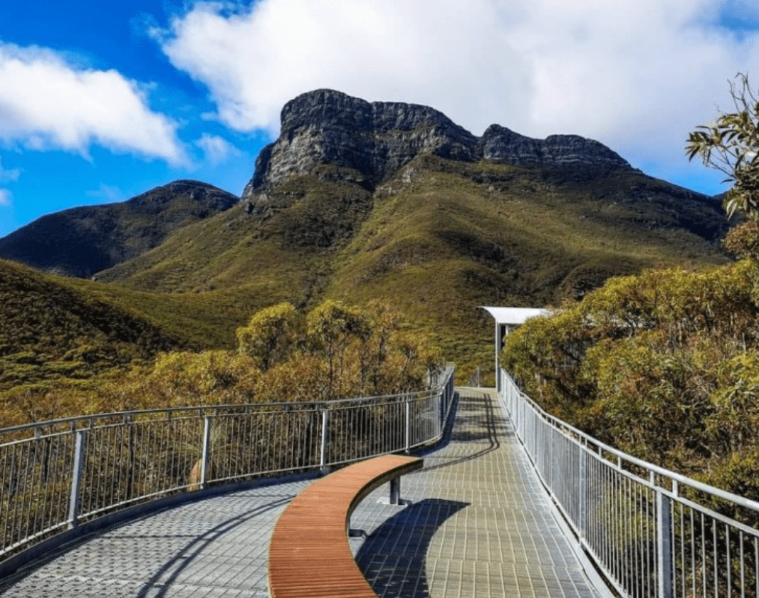
Learn more

Bluff Knoll is the most popular trail in the Stirling Range NP. Starting from the southern end of the Bluff Knoll car park the trail drops down to a creek, before taking you across a mountain saddle with amazing views over the ridge to the south coast. 

From here the trail turns left and follows the ridge all the way to the summit, where you will be rewarded with stunning 360 degree views over the surrounding countryside.

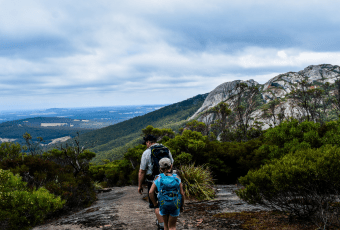
The lower slopes are covered with eucalypt, banksia and grass trees. Over 1000 species of flowering plants thrive within the park including Mountain Bells and the Queen of Sheba Orchid. 

It is often much colder and windier at the summit and conditions can change rapidly, so check the weather forecast and go prepared with a warm jacket. 

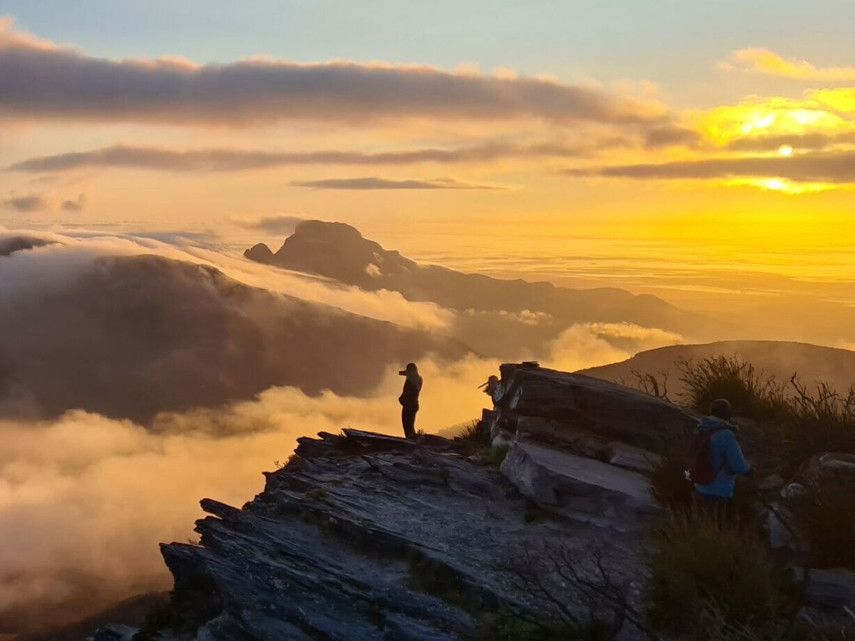
Sunrise and sunset hikes are very popular and if you are lucky you may witness the amazing cloud waterfall that is common in these ranges.

Visit the Explore Parks website for details of other walks in the area.

Albany Visitor Centre

(08) 6820 3700

Other Links

Expand your trip and enjoy great businesses nearby

Off The Beaten Track WA

Off The Beaten Track WA (OTBT) is Perth’s leading premier Hiking Experience & Adventure Tour operator, providing guests with over 70 safe, fun, inclusive experiences in a fully supported environment.

Photo of Off The Beaten Track WA

Be trail ready for Bluff Knoll, Stirling Range NP

Here is everything you need to know before visiting this trail.

Time / Duration

3 - 4 hours

Length

6.8km return

What To Pack

Group B (Bushwalks and/or longer trails) required.

Trail Start

Bluff Knoll car park, Stirling Range National Park, 100km (1 Hour) north-east of Albany, which is 400km (5 hours) south of Perth

Get directions

Trail End

Get directions

Bush Walk

Class 4

Difficult trail with rough surface that may have very steep hills or extensive rock hopping. Directional signage may be limited. Bushwalking experience, navigation and emergency first aid skills, and good fitness required.

Visit Trail Tips for further information.

Difficulty Notes

There are lots of steps along this trail

Hazards & Warnings

Weather can change quickly. Always take a warm jumper or jacket with you. The trail surface is a combination of bitumen, gravel and rock, so caution is advised.

Facilities

Information shelters
  • Car Park
  • All accessible parking
  • Picnic Area
  • Public Toilet
  • Water Access Points

Best time of year

August to November for wildflowers

Fees

Entry fees to Stirling Range National Park

Trail Access

Road, bus or air to Albany. Road to Stirling Range

Prohibited Items

No pets permitted. Camping is not allowed in the carpark or anywhere on the mountain/trail
Edge shaped like mountain horizon
topography pattern

Complete Bluff Knoll, Stirling Range NP to earn badges and points!

Earn points and badges and become a "TrailsWA Expert" by completing trails and leaving reviews.

Earn 2 Points

Earn 2 points towards
your TrailsWA level

Bluff Knoll Tall Peak Popular Trail Stirling Range Peaks

Earn the Bluff Knoll , Tall Peak , and Popular Trail badges when you complete this trail.

This trail is part of the Stirling Range Peaks badge.

Edge shaped like mountain horizon
Alt text

25 trail goers have rated Bluff Knoll, Stirling Range NP as 4.72 out of 5!

We love to hear from people who've been on our Western Australian trails, so it would be most appreciated it if you wanted to leave a review.

jake Hill

Reviewed 6 Jan 2024, 6:22pm

Bluff knoll was a great little treck, I completed it 4/01/2024, it was overcast and about 14 degrees C when we started at 3:00am, we stayed plenty warmas we moved along despite the cool weather. The nightlife was awesome and the clearly marked trail was well maintained. by the time we had reached the summit the wind was up, approx 20 km/H the temperature had dropped and it was borderline wet. IT WAS AWESOME and i would do it again next week given the chance. it took about an hour and a half at a slow pace. overall I would say that an average fitness level is required don't under-estimate how much of a difference handwarmers/gloves/scarf can make if your worried about the cold. My friends and I stayed at the Mt Trio campsite, it was well maintained with more facilities then we're used to at a very affordable price.
Richard Norman

Reviewed 1 Oct 2023, 4:29pm

Magnificent views and a challenging walk for 71yo.It took 90 minutes up and 75 down. The strong wind added to the challenge. Well worth venture.
Rachael I’Anson

Reviewed 26 Sep 2023, 9:08pm

Went today with our family. Challenging in parts. But worth the climb. View is beautiful. Took us four hours including lunch at the top.
Bruce Weiland

Reviewed 8 Nov 2022, 3:01pm

I did the climb about 8 years ago. At 66 yo it's tougher now but still a fun challenge. My 39 yo daughter from Adelaide also loved the challenge despite half of the hill being shrouded in cloud, occasional drizzle, rain at the summit, and rivulets of water cascading down the trail in places!! 5 stars even without any views. Yes, lots of steps. Probably harder than longer but more gradual Mt Augustus summit climb.
Steve McBride

Reviewed 20 Jul 2022, 7:49pm

Done Bluff Knoll several times but find it best early in the morning. Depending on clouds always provides different perspectives and lighting along the ranges. Be aware that the steps are quite high so coming down especially can be tough on the knees.
Chelle Fisher

Reviewed 5 Jun 2022, 9:50pm

Love the Bluff and have been fortunate enough to experience snow with my daughter
Olivia Brookes

Reviewed 17 Oct 2021, 8:43am

Fantastic views all along the hike. Can be quite difficult with the multiple steps but reward at the summit is well worth it. Much easier on the way day down but can be harsh on the knees and ankles. Prepare for change in weather as we experienced hot weather, rain and then extreme wind all in 4 hours !!
Miss T

Reviewed 18 Jan 2021, 12:43pm

Incredibly well constructed and maintained track. Mostly built treads constructed with rocks and reinforced with timber - so very stable in all weather. Don't be afraid of the changing weather - you get interesting views of clouds passing through the Stirling ranges. Plenty of wildflowers. One of the few trails where you can enjoy the scenery because you don't need to watch for trip hazards!
Peta Graham

Reviewed 30 Nov 2019, 8:02pm

Awesome trail. Is a bit hard on knees in places. But worth the effort. The view is amazing !!!!
Pete E

Reviewed 29 Oct 2018, 9:52pm

https://www.wikiloc.com/hiking-trails/bluff-knoll-30059247
David Hurdle

Reviewed 24 Jun 2018, 9:37pm

Walked it June 2018. The millions of steps (it felt like that many) was a bit hard on the knees but that's ok.

At the moment the track is wet and a little muddy. There is some flowing water (not deep, just enough to wet you shoes) in parts.

The May bush fired have blackened the very top few hundred metres. Doesn't really detract from the experience and hopefully won't cause to much erosion.

We met a lots of underprepared people on the way, white jeans, dress shoes, no water or carry a toddler. Hopefully they had the sense to turn around.
Sarah Nevison

Reviewed 8 May 2018, 1:32pm

What a beautiful walk! Despite having to get up at 3am to see the sunrise from the top, it was absolutely worth the hike. Such a beautiful view from the top and not to much of a hike. Keep in mind there are a lot of steps, up the first section, so it's a bit difficult to begin with, so take it easy.
Nicole HS

Reviewed 6 Jan 2018, 3:52pm

When: December
Temp: 24 C
Start Time: 11AM

Definitely worth the struggle. The hardest part is the middle section (so keep persevering!) The last third of the walk is just lovely, the elevation allows you to see on all sides of the mountain and you get a really nice breeze. The walk is also not as steep towards the peak. The views at the top are amazing giving you 360 degree vantage. Stopped many times on the way up because I really struggled to it took about 3 hrs up. Then 45 mins back down because we ran the whole way back down.
Anne Ellis

Reviewed 20 May 2017, 9:06am

An amazing experience. We went in January, on a day when it was 28 degrees and sunny. We needed a LOT of water as the way is all uphill and quite challenging - especially for those amongst us who are not very fit (ie me!). It took us 6 hours return in total. We had 2 adults, a 17yr old and two 10yr olds in our family. If you have any problems with knees at all, I recommend climbing sticks. The way up has steps a lot of the way which is better then sliding around on steep gradients, but was very hard on my knees. Coming down was equally as difficult - I was turning sideways to step down many of the stairs as they were quite high. The climbing sticks were invaluable. Allow plenty of time - I know the official rating is 1-3hours, but I think the 1hour can only be for those people we saw running up Bluff Knoll! (Yes indeed, running!!). Great views from the top. And rocks to lie on and recover your breath before heading back down.
Tamara White

Reviewed 2 Apr 2017, 3:58pm

I had waited a long time to do this trail and talked about it for two years so when we finally got a chance to go down in the middle of summer I hoped the weather would not be too hot for it, quite the opposite, it rained for two days so we had to put it off. We finally had a clear day on 1 Jan and got there around 6am. Given my fitness was still not up to scratch it took us a good 6 hours to do the return trip - but it was so worth it!! Halfway up we met a family from Sweden (overtaking us) and they had a massive horn with them, one of them stopped on a ledge and played for about 20 mins - it was magical. I loved it and could have stayed on top for ages, though it is a shame that people have been taking bathrooms breaks up there!! Just wish I had remembered the Thermos of coffee so we could have enjoyed it more. Coming down was much harder than going up - on the knees mostly.
Cynthia Van der Wielen

Reviewed 9 Oct 2016, 8:27pm

Amazing. The climb up to the summit of Bluff Knoll is an experience not to be missed. The views are amazing from any vantage point, I recommend doing the trek early as Bluff Knoll is very popular with tourists, and it is is of course cooler!
Cassie Paxman

Reviewed 7 Aug 2016, 9:11pm

Fantastic walk. We started walking at 5am and got to the top just as the sun was rising at 6.30ish. Definitely recommended but make sure it's a clear day or the sunrise at the top won't be as rewarding!
Alan Boyd

Reviewed 14 Jun 2016, 11:46am

Great track to walk and the views at the toip are well worth it. Pack food and plenty of water but remember to take your rubbish with you as there are no bins at all. Pack warm and water proof clothing as the weather can change especially in the cooler months of the year, when I did the track last weekend some rain moved in, nothing too heavy but it was quite cold, I saw some person coming down the track in shorts and a hoody and her legs were pink from the cold! Having the mountains in the Stirlings shrouded in cloud and mist was spectactular. Allow at least 3-4 hours depending on fitness.
Lauren McCabe

Reviewed 4 May 2016, 7:54pm

Definitely want to do this one again. It is 3-4hours return not 1-3 (just so you know). It is challenging in the sense it is quite steep but the path is well maintained and the walk has stairs so you are not scrambling on slippery rocks. If you are fit or prepared to take breaks this hike is well worth the effort. Bring adequate water and clothing as the weather changes quite quickly. Remember to stop and look behind you; the view is ever changing and sometimes the best view is just behind you. PLEASE take your rubbish home with you, I picked up rubbish at the top of this climb. It is beautiful, let's keep it that way.
Lorentz Henny

Reviewed 19 Mar 2016, 11:27pm

Great hike, both a challenge and a major reward when you reach the summit.
Ally Catt

Reviewed 3 Oct 2015, 8:15am

This track took us just over 3 hours and it is certainly hard work if you have asthma so be prepared!
We sat and ate while enjoying the amazing view at the top and were very lucky to hike on a clear day.
Dont give up half way like so sooo many people i met along the way.. its worth the stuggle to get to the top
Lee lee

Reviewed 7 Jul 2015, 5:14pm

Challenging but rewarding walk. Its uphill the entire way and the scenery is remarkably different to W.A. On the morning we hiked the trail it was windy and raining with lots of cloud cover. Was still ALOT of fun and incredible to make it to the top. Would like to return on a clear day to see the view. Lower down, on the way back down the clouds cleared and gave us a tease. Saw quite a few families doing the trail. Take your time and enjoy. Bring water and snacks, fruit. It might be sunny below on the ground, however, the weather changes and it could be raining cats and dogs on top. Bring a rain jacket. We tried those cheap ponchos however the wind was so strong it was blowing them over our faces, abandoned them and just got wet!
Linda Malinowski

Reviewed 24 Feb 2015, 8:50am

Pick a clear day - no clouds! During hotter months, start as early as possible. Take lots of water, sun block, hat, good walking/hiking shoes. A reasonable level of fitness is required. The reward for your efforts, is an amazing 360 degree view from the top ... all the way to Bremer Bay! Have only done this in Winter and Summer, but I imagine the wildflowers will be spectacular, in season.
Scott Hawker

Reviewed 26 Jul 2014, 9:07pm

Great hike/run. Over 700m elevation gain in 3km is fantastic. The trail is well maintained and is pretty much suitable for anyone keen to head up. The views from the top are awesome. The only Alpine like terrain in WA I have come across. A must do!
Sally Westlake

Reviewed 25 Apr 2014, 1:15pm

Excellent trail, absolutely stunning. Need plenty of water, good walking shoes, not great for really little kids, a fairly advanced trail.

Like this trail? Explore others nearby

More around South West

Supported by great organisations

Trails are free and bring so many benefits to our community by providing opportunities to have fun, get fit, socialise, explore and challenge yourself. But they also have to be managed and maintained which only is made possible through terrific sponsors, donations and/or volunteering.

topography pattern