Forest Explorers - Wildflower, Mural, Heritage Tours & Trail Transfers
Small group tours & transfers embracing connections with Wildflowers, Murals, Heritage trails.


Trails WA supports the seven principles recommended by Leave No Trace Australia for minimising your impacts when using the trails.
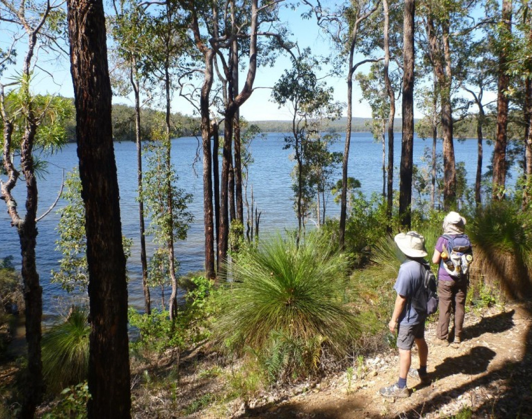
Learn moreThe Wellington Spur Trail links the Bibbulmun Track just south of Collie, to the Wellington Dam recreation area in the Wellington National Park. It is a pretty walk through the Wellington National Park which features WA’s unique eucalypt forests of jarrah, marri and yarri (blackbutt).
The two group campsites (Lyall’s Mill and Arcadia) have undercover areas, tables, toilets and tent sites but no sleeping shelters. The maximum group size is 30. At all other campsites on the Bibbulmun Track the maximum size of any group staying overnight is 17, including leaders.
The trail is marked with the same trail marker as the Bibbulmun Track (a stylised Waugal) but with a green background instead of yellow.
Day 1. Walk the Bibbulmun Track to Yabberup Campsite which is 19.6km south of Collie. (To shorten the walk, get dropped of at Mungalup Road Bridge 13.7km or Mungalup Road South 10.4km. These vehicle drop-off points are shown on the map.)
Lyall's Mill group campsite is approximately 350 metres away from Yabberup campsite (300m from the spur/Track junction).
Day 2. The 15km walk from Lyalls Mill campsite to Arcadia Campsite takes you through jarrah forest with occasional valley views.
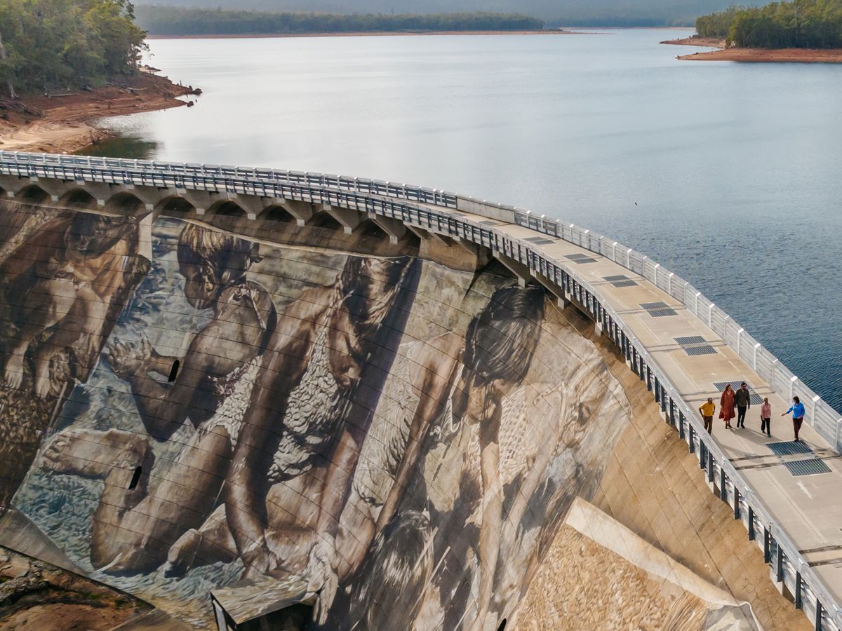
Day 3. A short 3.5km hike to Wellington Dam leaves time to explore the Dam recreation area. Camping is also available in the area.
Same itinerary as above but commence your walk at Glen Mervn Dam. Follow the Bibbulmun Track for 6kms to the start of the spur trail. This provides a shorter first day's walk depending on the age of the group and/or the travel time to get to the drop-off/pick-up point.
Starting the walk at the Dam into Arcadia campsite and back is a good day walk or overnight option for younger age groups.
Starting point: Drive (or walk) from the Kiosk down Wellington Dam Road to the base of the dam wall. Just a little further on from the river crossing there’s a small parking area where you’ll find the Trailhead sign. Walk up the bitumen road and the trail starts on the right of the dam wall.
All groups need to lodge a Notice of Intent (NOI) form with the Bibbulmun Track Foundation. For more information and a host of expedition planning resources visit the Bibbulmun Track Foundation website.
(08) 9734 2051
These pages provide youth group leaders with the necessary tools to plan, lead and complete a successful expedition on the Bibbulmun Track.
Situated amongst the magnificent jarrah forest of the Wellington National Park, this centre offers eco-education experiences that give an insight into jarrah forest ecology and past management of the forest.
Wellington Forest Cottages and Conference Centre is just 10kms from Wellington Dam and within walking distance of the Wellington Forest Discovery Centre. There are 8 cottages that sleep up to 8 people each (one double bed).
Hire a bike, have a delicious bite to eat or book your camp accommodation (for other campsites in the area) at the Kiosk.
The Group Notification provides Parks and Wildlife Services with information regarding your planned group activity, to help sustain the biodiversity and conservation values of the diverse environments the tracks and trails traverse. The Group Notification also assists in considering the needs and enjoyment of other Track users by preventing overcrowding in campsites and/or potential clashes of expedition dates of groups
Comprehensive information on the South West region including destinations, things to see and do, accommodation and tours.
Small group tours & transfers embracing connections with Wildflowers, Murals, Heritage trails.
A country retreat on 50 acres overlooking the Ferguson Hills, with the Bibbulmun Track passing the along the edge of property.

Here is everything you need to know before visiting this trail.
Time depends on length and section of trail chosen
19km one way
Group B - Hiking & Long Distance Trails (Bushwalks and/or longer trails) required.
Group B - Hiking & Long Distance Trails (Bushwalks and/or longer trails)
On foot via the Bibbulmun Track (see trail notes) or Wellington Dam, which is 200km (2.5) hours south of Perth

Class 4
Difficult trail with rough surface that may have very steep hills or extensive rock hopping. Directional signage may be limited. Bushwalking experience, navigation and emergency first aid skills, and good fitness required.
Visit Trail Tips for further information.
April to November
Road 2WD


Earn points and badges and become a "TrailsWA Expert" by completing trails and leaving reviews.
Earn 3 points towards
your TrailsWA level
Earn the Overnight Hike , and Bibbulmun Track badges when you complete this trail.


We love to hear from people who've been on our Western Australian trails, so it would be most appreciated it if you wanted to leave a review.


Trails are free and bring so many benefits to our community by providing opportunities to have fun, get fit, socialise, explore and challenge yourself. But they also have to be managed and maintained which only is made possible through terrific sponsors, donations and/or volunteering.


View 6 Photos of Bibbulmun Wellington Spur Trail, Wellington NP
You are reporting a problem for Bibbulmun Wellington Spur Trail, Wellington NP. Please be as detailed as possible to help us appropriately identify and address the issue.

Join trails wa to add this trail to your favourite. By joining you will also be able to rate and review trails and share your photos with other trail goers!
Sign in to your account to add this trail to your list of favourites, and much more.

