Skip to Content Skip to Navigation Show Trail Map Show About the Trail Show Important Trail Details Read Trail Reviews
Support Our Trails

Bald Head Walk Trail, Torndirrup NP Bald Head Walk Trail, Torndirrup NP

Bush Walk

(+1)
Trail Running
 in South West

  • Full day
  • 12.5 km
    • Bush Walk Class 4

      Difficult trail with rough surface that may have very steep hills or extensive rock hopping. Directional signage may be limited. Bushwalking experience, navigation and emergency first aid skills, and good fitness required.

Located in the spectacular Torndirrup National Park, the Bald Head Walk Trail is a challenging 12.5 kilometre return traverse of the Flinders Peninsula providing stunning views of the Southern Ocean and King George Sound.  This rewarding hike won’t leave you wanting for more and has a number of great photographic opportunities.

Bald Head 5 Torndirrup Dbca Resized
Earn 3 Points Popular Trail
Logo for Leave no Trace Initiative

Trails WA supports the seven principles recommended by Leave No Trace Australia for minimising your impacts when using the trails.

Learn more

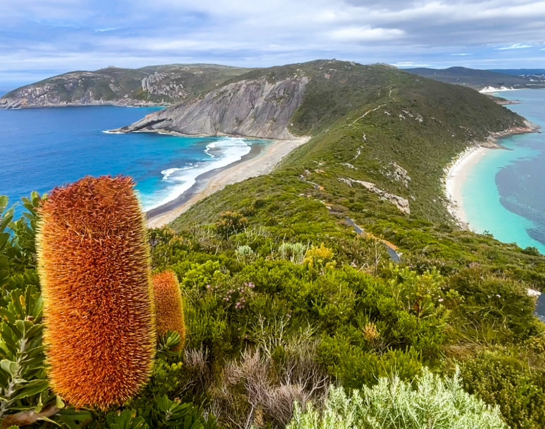
While the Torndirrup National Park, located a short 10 minute drive from Albany, is more famous for tourist attractions such as the Blowholes, Natural Bridge and The Gap, it hides one of the best hikes in the South West. The trail climbs and descends along the narrow ridge line of the Flinders Peninsula, a granite formation that juts out from the landscape into the vastness of the Southern Ocean.

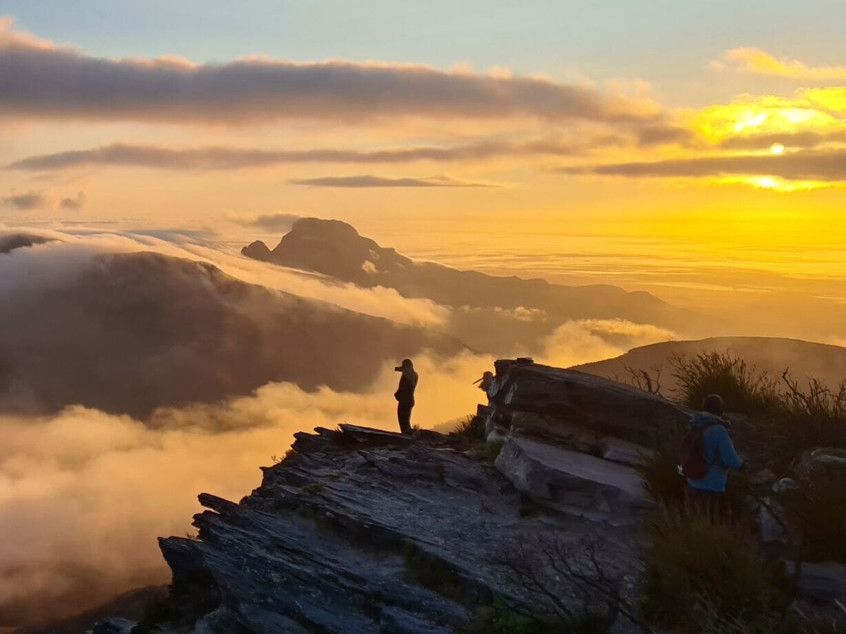
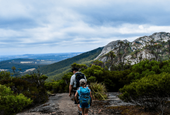
Hard core bushwalkers will enjoy this 12.5km return, 6-8 hour hike over Isthmus Hill to Flinders Peninsula and on to Limestone Head and Bald Head.  Terrain is steep and difficult in sections.  

The walk ends at Bald Head, a round headland of domed granite sloping down into the ocean and can be seen from many places along the Torndirrup Coast.

Taking in a combination of boardwalk, packed limestone paths and hard granite sections, there is a great variety of things to see and photograph on the trail. Along with the spectacular views of the granite cliffs, the views back to Albany and King George Sound are breathtaking. If you are visiting Albany and have the time then put the Bald Head Walk Trail on your list of things to do. A high degree of fitness is required.

Visit Albany

Albany is a world-class hiker's paradise - with its stunning coastline, pristine nature reserves and proximity to one of the oldest mountain ranges in the world. 


There truly is something for everyone in Albany, from gourmet wine-lovers, to intrepid 4WD explorers, to backpackers – and everyone in between. World-class wine, food, fishing, surfing, swimming, diving, hiking, mountain biking, four-wheel-driving, camping and myriad other activities are all on offer within minutes of town.

Explore Albany
Visit Albany

Albany Visitor Centre

(08) 6820 3700

National Parks

Other Links

Expand your trip and enjoy great businesses nearby

Off The Beaten Track WA

Off The Beaten Track WA (OTBT) is Perth’s leading premier Hiking Experience & Adventure Tour operator, providing guests with over 70 safe, fun, inclusive experiences in a fully supported environment.

Photo of Off The Beaten Track WA

Be trail ready for Bald Head Walk Trail, Torndirrup NP

Here is everything you need to know before visiting this trail.

Time / Duration

5 - 7 hours

Length

12.5 kilometres return

What To Pack

Group B (Bushwalks and/or longer trails) required.

Trail Start

Off Murray Rd, Torndirrup National Park - 400km (5 hours) south of Perth

Get directions

Trail End

Bald Head

Bush Walk

Class 4

Difficult trail with rough surface that may have very steep hills or extensive rock hopping. Directional signage may be limited. Bushwalking experience, navigation and emergency first aid skills, and good fitness required.

Visit Trail Tips for further information.

Difficulty Notes

Terrain is steep and difficult in sections. Do not attempt to return via the beaches due to unseen hazards.

Hazards & Warnings

Be careful on the granite sections and around the edges as the cliffs are quite steep.

Facilities

  • Car Park

Best time of year

All Year Round

Trail Access

Road 2WD

Prohibited Items

No pets or bikes
Edge shaped like mountain horizon
topography pattern

Complete Bald Head Walk Trail, Torndirrup NP to earn badges and points!

Earn points and badges and become a "TrailsWA Expert" by completing trails and leaving reviews.

Earn 3 Points

Earn 3 points towards
your TrailsWA level

Popular Trail

Earn the Popular Trail badge when you complete this trail.

Edge shaped like mountain horizon
Alt text

16 trail goers have rated Bald Head Walk Trail, Torndirrup NP as 4.56 out of 5!

We love to hear from people who've been on our Western Australian trails, so it would be most appreciated it if you wanted to leave a review.

Nicole Roses

Reviewed 2 Feb 2024, 1:37pm

Beautiful nature trail with stunning views to both sides of the peninsula
Haylee Ramsay

Reviewed 7 Jan 2024, 6:02pm

Excellent track, views well worth the effort. Highly recommend.
Rachael I’Anson

Reviewed 7 Oct 2023, 6:20pm

Took us 4 hours - family of 5.
Beautiful views. And colour of the water.
We will be back.
Garry Young

Reviewed 31 Jul 2023, 2:03pm

Just turned 70 years when my wife and I completed the Bald Head hike in January 2023. Quite difficult but significant and beautiful views over coast and into harbour entrance. Make sure you take adequate water and food to keep energy level up - we did not have the latter. 100% worth the effort. We did it in 7 hours.
Natalia JH

Reviewed 4 Jun 2023, 5:34pm

Beautiful views, awesome trail. It's really challenging but worth it. If you're lucky, you'll see pods of whales.

We started early, 6.30am in the morning to see the sunrise. It took us 5 hours plus half an hour break at the end. Finished the track by lunch time. We still had half a day to visit other places and relax.
Deborah Hallows

Reviewed 27 Jan 2023, 7:16am

Amazing upgrade except signage along trial would be helpful!
Chelle Fisher

Reviewed 1 Jun 2022, 7:48pm

Without a doubt the best trail in the region. A 12.5 return hike that provides spectacular views of coastal scenery off the Flinders Peninsula in Torndirrup National Park. Walkers are rewarded with breathtaking views of the coastline along the trail and at the end of the track
Ben Morse

Reviewed 14 May 2021, 4:13pm

Best trail I've walked..
It offers everything from rock, sand, man made, views, weather and challenge.

I was approximately 5.5hrs on the trail did it solo and stopped for small lunch on the head and few pics on the way back.

Signage is only done by rocks built up in areas were coming off, or through granent sections. Be sure to keep an eye out for these pyramid style placed rocks.

Pack well, its nice to have some essentials on the way and be comfortable.

Car park has spaces for bout 6 cars.
Happy hiking
Bob Peters

Reviewed 12 Feb 2020, 12:36pm

Outstanding walk. The best in Western Australia. World class.
Leanne Storer

Reviewed 10 Dec 2019, 7:05am

This is an amazing trail with spectacular views. I managed it solo in 4.5hrs (was on a bucket-list mission) with a low-medium fitness level however some parts were pretty tough going as they were steep, sandy and had plenty of trip hazards (plant roots, rocks etc). It was a great adventure having to locate the next wooden post or rock pile so as to navigate the path in places and passage through the overgrown sections bought back childhood memories. I highly recommend bug spray as the March flies were quite relentless in early December. Next time I'll SLOW DOWN and take my kids for sure! The hardest part I think was the steep downhill metal boardwalk on the return right at the end.. makes your legs burn and turn to jelly!! Highly recommended... just go prepared with water, snacks, first aid kit.. phone reception was pretty good the whole way.
Naomi O'Shea

Reviewed 17 Jan 2019, 7:28pm

You don't have to do the whole trail if you don't have time. An hour is plenty of time to walk to the ridge with the water either side. It is only 1 km to that part and it is spectacular. Sneakers and a bottle of water will suffice.
Profile photo for Marco Zecca
Marco Zecca

Reviewed 26 Sep 2018, 1:55pm

Trail completed on the Easter long weekend. Long but not too challenging. The scenery is truly spectacular and the surrounding surprisingly changes along the way. Highly recommended!
Gerard Cameron

Reviewed 16 Apr 2018, 4:30am

We did the trail yesterday in a group of 8 friends. First of all 4 participants had Garmin watches. All came up with a total of 13.2 kms total. return. Interesting to note that the trail is quite overgrown now in some parts. Still well and truly passable though. It took us 5 hours return. We stopped for lunch and snacks and walked at a leisurely rate. Last time we did it in 4 hours without pushing too hard. Certainly a few difficult steep sections. The view is simply stunning all the way through. Every new corner gives you views of King George Sound and the Southern Ocean that are simply stunning. Can't recommend this trail enough.
Alan Boyd

Reviewed 14 Jun 2016, 11:38am

I was down in Albany last weekend for the WA Day long weekend and had been planning to walk this trail and I was not disappointed, it was an amazing hike with brilliant views in any direction. The trail does seem a bit degraded in a few loctions, on the return leg I had to scramble/climb up at two or three locations. I also tracked the return leg of the hike on my Garmin and it came in at 6.55km (that was to the carpark) so I'm not sure whether the 16km return figure is accurate, I did it in about 4 and a half hours but having said that the terrain is difficult at times so do not go unprepared! Will check this hike out the next time I'm down in Albany.
Margaret Owens

Reviewed 18 Dec 2015, 8:55pm

Obviously the details for this walk should read 16kms not 6kms. The walk is amazing but is very degraded in parts where the down slopes have broken away. Stunning views over the whole of Pricess Royal Harbour. Take plenty of water and don't underestimate the terrain. I have walked this trail over 20 yrs and am surprised how parts are needing repair but there has been some work along the way.
Brad Mills

Reviewed 10 Dec 2015, 9:16am

This trail is amazing from start to finish, spectacular views in every direction, make sure to take camera.
This site says it is a 12km return walk though at the signage at start of walk it says 16km return walk.... I believe it is 16km but want to follow that up.
This walk is quite steep and strenuous in certain spots but well worth it.
Be aware of tiger snakes... I was lucky enough not to confront any, though I did see alot of fresh snake trails.
I did the walk alone so I had some snake proof gaitors and snake first aid kit, in all honesty it would have been more comforting to have done the walk with someone else for safety reasons such as snake bite or injury.
Phone signal drops in and out in certain places and it is quite a secluded remote walk, so on your own you may not get any help if needed quickly.
This is an epic walk I loved every moment.....but still sore a couple days later

Like this trail? Explore others nearby

More around South West

Supported by great organisations

Trails are free and bring so many benefits to our community by providing opportunities to have fun, get fit, socialise, explore and challenge yourself. But they also have to be managed and maintained which only is made possible through terrific sponsors, donations and/or volunteering.

topography pattern